IMAGES TAKEN NEAR TO
Minster Crescent, LEICESTER, LE4 0JB
Introduction
This page details the photographs taken nearby to Minster Crescent, LE4 0JB by members of the Geograph project.
The Geograph project started in 2005 with the aim of publishing, organising and preserving representative images for every square kilometre of Great Britain, Ireland and the Isle of Man.

There are currently over 7.5m images from over14,400 individuals and you can help contribute to the project by visiting https://www.geograph.org.uk
Image Map (Loading...)


Getting Data...Please wait
Leaflet Map data © OpenStreetMap
Images are licensed for reuse under creativecommons.org/licenses/by-sa/2.0
Notes
- Clicking on the map will re-center to the selected point.
- The higher the marker number, the further away the image location is from the centre of the postcode.
Image Listing (6 Images Found)
Images are licensed for reuse under creativecommons.org/licenses/by-sa/2.0
Image
Details
Distance
1
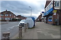
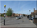
Somerset Avenue, Leicester
Photographed from its junction with Burnham Drive.
Image: © Mat Fascione
Taken: 5 Apr 2007
0.04 miles
2
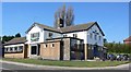
The John O Gaunt Public House
At the junction of Somerset Avenue and Wiltshire Road.
Image: © Mat Fascione
Taken: 5 Apr 2007
0.05 miles
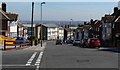
5
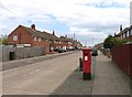
Cheltenham Road
Showing pillar box LE4 737!
Image: © Andrew Tatlow
Taken: 3 May 2013
0.23 miles