IMAGES TAKEN NEAR TO
Ravensbridge Drive, LEICESTER, LE4 0BZ
Introduction
This page details the photographs taken nearby to Ravensbridge Drive, LE4 0BZ by members of the Geograph project.
The Geograph project started in 2005 with the aim of publishing, organising and preserving representative images for every square kilometre of Great Britain, Ireland and the Isle of Man.

There are currently over 7.5m images from over14,400 individuals and you can help contribute to the project by visiting https://www.geograph.org.uk
Image Map
Images are licensed for reuse under creativecommons.org/licenses/by-sa/2.0
Notes
- Clicking on the map will re-center to the selected point.
- The higher the marker number, the further away the image location is from the centre of the postcode.
Image Listing (97 Images Found)
Images are licensed for reuse under creativecommons.org/licenses/by-sa/2.0
Image
Details
Distance
1
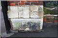
Benchmark on gatepost at entrance to Abbey Park from St Margaret's Way
Ordnance Survey cut mark benchmark described on the Bench Mark Database at http://www.bench-marks.org.uk/bm63671
Image: © Roger Templeman
Taken: 6 Jan 2015
0.07 miles
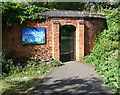
2
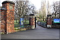
Entrance to Abbey Park from St Margaret's Way
There is an OS benchmark Image on the right hand gatepost
Image: © Roger Templeman
Taken: 6 Jan 2015
0.07 miles
3
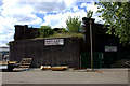
Bridge remnants near St Margaret's Way
Remains of the old Great Central Railway line.
Image: © Robert Eva
Taken: 14 Jun 2018
0.08 miles
4
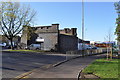
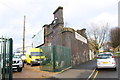
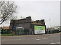
Isolated Viaduct
Not much remains of Leicesters expansive viaduct, most has been demolished, some recently. The left part of this section went in 2004. See also Image]
Image: © Ashley Dace
Taken: 13 Nov 2010
0.09 miles
5
Remains of railway bridge over Abbey Gate
Image: © Roger Templeman
Taken: 6 Jan 2015
0.10 miles
7
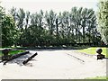
Abbey Park, Leicester
This now disused paddling pool was built in 1930 and was a source of much enjoyment for many local people according to past newspaper accounts. Almost constant traffic noise from the A6 (a.k.a. St Margaret's Way), beyond the boundary wall, is now a prominent feature of this part of the park.
Image: © David Hallam-Jones
Taken: 3 Sep 2019
0.11 miles
8
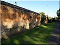
Remnant of the Great Central Main Line, St Margaret's Way, Leicester
Part of a fast rail route between Manchester/Sheffield and London built in the 1890s - the last main line railway to be built in Britain during the Victorian period https://en.wikipedia.org/wiki/Great_Central_Main_Line . This section closed in the 1960s.
Image: © Tim Heaton
Taken: 26 Apr 2022
0.12 miles
9
South entrance to Abbey Park, Leicester
Image: © Mat Fascione
Taken: 30 May 2010
0.13 miles
10
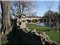
Abbey Park, with bridge over River Soar, Leicester
Image: © Tim Heaton
Taken: 26 Feb 2012
0.13 miles