IMAGES TAKEN NEAR TO
Pindar Road, LEICESTER, LE3 9RH
Introduction
This page details the photographs taken nearby to Pindar Road, LE3 9RH by members of the Geograph project.
The Geograph project started in 2005 with the aim of publishing, organising and preserving representative images for every square kilometre of Great Britain, Ireland and the Isle of Man.

There are currently over 7.5m images from over14,400 individuals and you can help contribute to the project by visiting https://www.geograph.org.uk
Image Map
Images are licensed for reuse under creativecommons.org/licenses/by-sa/2.0
Notes
- Clicking on the map will re-center to the selected point.
- The higher the marker number, the further away the image location is from the centre of the postcode.
Image Listing (19 Images Found)
Images are licensed for reuse under creativecommons.org/licenses/by-sa/2.0
Image
Details
Distance
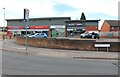
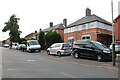
2
Rocket Public House Leicester
Looking towards Stephenson Drive
Image: © tony ellis
Taken: 1 May 2008
0.10 miles
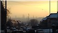

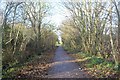
7

Forest Way cycleway and footpath
Following the route of the former Leicester to Swannington Railway.
Image: © Mat Fascione
Taken: 23 Sep 2017
0.21 miles
8
Leicester to Swannington Railway
The cycleway with West Bridge behind me.
Image: © Ashley Dace
Taken: 7 Dec 2011
0.21 miles
9
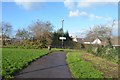
Leicester to Swannington Railway
The course of the line has been built on. The cycleway continues left and right with West Bridge behind me.
Image: © Ashley Dace
Taken: 7 Dec 2011
0.21 miles