IMAGES TAKEN NEAR TO
Groby Road, LEICESTER, LE3 9QF
Introduction
This page details the photographs taken nearby to Groby Road, LE3 9QF by members of the Geograph project.
The Geograph project started in 2005 with the aim of publishing, organising and preserving representative images for every square kilometre of Great Britain, Ireland and the Isle of Man.

There are currently over 7.5m images from over14,400 individuals and you can help contribute to the project by visiting https://www.geograph.org.uk
Image Map
Images are licensed for reuse under creativecommons.org/licenses/by-sa/2.0
Notes
- Clicking on the map will re-center to the selected point.
- The higher the marker number, the further away the image location is from the centre of the postcode.
Image Listing (6 Images Found)
Images are licensed for reuse under creativecommons.org/licenses/by-sa/2.0
Image
Details
Distance
2
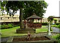
Peaceful garden at Glenfield Hospital
Image: © Andrew Tatlow
Taken: 24 Jun 2008
0.17 miles
3
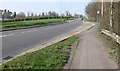
Looking north along Glenfrith Way, Leicester.
Image: © Mat Fascione
Taken: 1 Apr 2007
0.19 miles
4
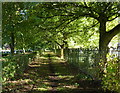
Tree lined path through Gilroes Cemetery
Image: © Mat Fascione
Taken: 2 Oct 2016
0.24 miles
5
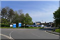
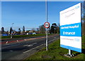
Entrance to Glenfield Hospital
Specialising in care for heart and respiratory problems
Image: © Tim Heaton
Taken: 19 Apr 2019
0.25 miles
6
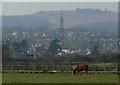
Looking across farmland towards Anstey and Bradgate Park.
Image: © Mat Fascione
Taken: 1 Apr 2007
0.25 miles