IMAGES TAKEN NEAR TO
Mossgate, LEICESTER, LE3 9JW
Introduction
This page details the photographs taken nearby to Mossgate, LE3 9JW by members of the Geograph project.
The Geograph project started in 2005 with the aim of publishing, organising and preserving representative images for every square kilometre of Great Britain, Ireland and the Isle of Man.

There are currently over 7.5m images from over14,400 individuals and you can help contribute to the project by visiting https://www.geograph.org.uk
Image Map (Loading...)


Getting Data...Please wait
Leaflet Map data © OpenStreetMap
Images are licensed for reuse under creativecommons.org/licenses/by-sa/2.0
Notes
- Clicking on the map will re-center to the selected point.
- The higher the marker number, the further away the image location is from the centre of the postcode.
Image Listing (11 Images Found)
Images are licensed for reuse under creativecommons.org/licenses/by-sa/2.0
Image
Details
Distance
1
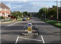
Aikman Avenue in New Parks
At the junction with Adcock Road.
Image: © Mat Fascione
Taken: 25 Sep 2010
0.04 miles
4
Coates Avenue, Leicester
Back in the 60s many distant suburban roads, including some post-war council estates, had beige surfaces of separate sheets. Many were like crazy paving joined with lines of tarmac while these are separate equal slabs which have cracked since. This is one of the few I have come across now.
Image: © David Howard
Taken: 2 Aug 2022
0.20 miles
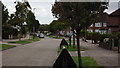
5
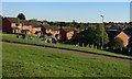
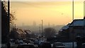
View across the city of Leicester
The view from Marvin Close in the Dane Hills area of Leicester.
Image: © Mat Fascione
Taken: 2 Oct 2019
0.20 miles
6
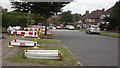
Letchworth Road, Leicester
Lots of work is being done on the gas mains!
Image: © John Welford
Taken: 9 Sep 2015
0.23 miles
7
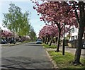
Blossom trees along Glenfield Road, Leicester
Image: © Mat Fascione
Taken: 15 Apr 2020
0.24 miles
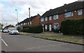
8
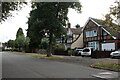
Letchworth Road, Leicester
This could easily be anywhere around Harrow as well.
Image: © David Howard
Taken: 2 Aug 2022
0.25 miles
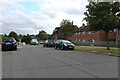
10
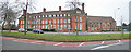
Highpoint Conference Centre, Glenfield Road, Leicester
This building was originally St Catherine's convent and chapel. It was bought by Leicester Housing association in 1997 but was subsequently converted into a conference centre which opened in 2002.
Image: © Kate Jewell
Taken: 6 Jan 2006
0.25 miles