IMAGES TAKEN NEAR TO
Stowe Close, LEICESTER, LE3 9ES
Introduction
This page details the photographs taken nearby to Stowe Close, LE3 9ES by members of the Geograph project.
The Geograph project started in 2005 with the aim of publishing, organising and preserving representative images for every square kilometre of Great Britain, Ireland and the Isle of Man.

There are currently over 7.5m images from over14,400 individuals and you can help contribute to the project by visiting https://www.geograph.org.uk
Image Map (Loading...)


Getting Data...Please wait
Leaflet Map data © OpenStreetMap
Images are licensed for reuse under creativecommons.org/licenses/by-sa/2.0
Notes
- Clicking on the map will re-center to the selected point.
- The higher the marker number, the further away the image location is from the centre of the postcode.
Image Listing (13 Images Found)
Images are licensed for reuse under creativecommons.org/licenses/by-sa/2.0
Image
Details
Distance
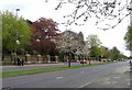
4
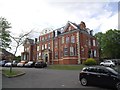
Rowlinson Court
This Victorian property has been converted into flats.
Image: © Tim Glover
Taken: 16 May 2015
0.14 miles
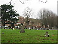
6
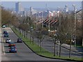
Looking southeast along Groby Road, Leicester.
The photo was taken close to the entrance to Gilroes Cemetery. Leicester city centre skyline is visible in the distance.
Image: © Mat Fascione
Taken: 1 Apr 2007
0.20 miles
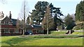
7
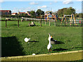
Gorse Hill City Farm, Anstey Road, Leicester
Voluntary community project with small scale humane farming, rare breeds and organic horticulture.
Image: © Kate Jewell
Taken: 1 Nov 2005
0.21 miles
8
Cyclepath along Groby Road in Leicester
Image: © Mat Fascione
Taken: 5 Nov 2017
0.22 miles
9
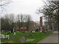
Groby Road passes Gilroes Cemetery and Crematorium
Image: © Andrew Tatlow
Taken: 3 May 2013
0.23 miles
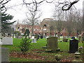
10
The main entrance to Gilroes Cemetery on Groby Road, Leicester.
Image: © Mat Fascione
Taken: 1 Apr 2007
0.24 miles