IMAGES TAKEN NEAR TO
Saddlers Close, LEICESTER, LE3 8QU
Introduction
This page details the photographs taken nearby to Saddlers Close, LE3 8QU by members of the Geograph project.
The Geograph project started in 2005 with the aim of publishing, organising and preserving representative images for every square kilometre of Great Britain, Ireland and the Isle of Man.

There are currently over 7.5m images from over14,400 individuals and you can help contribute to the project by visiting https://www.geograph.org.uk
Image Map (Loading...)


Getting Data...Please wait
Leaflet Map data © OpenStreetMap
Images are licensed for reuse under creativecommons.org/licenses/by-sa/2.0
Notes
- Clicking on the map will re-center to the selected point.
- The higher the marker number, the further away the image location is from the centre of the postcode.
Image Listing (26 Images Found)
Images are licensed for reuse under creativecommons.org/licenses/by-sa/2.0
Image
Details
Distance


6
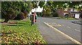
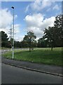
Flood relief basin in Glenfield
Next to Kirby Road and Elm Tree Avenue.
Image: © Mat Fascione
Taken: 29 Sep 2017
0.18 miles
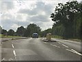
8

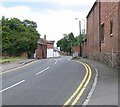
Kirby Road, Glenfield
Taken from close to the Forge Inn. Although not part of the City politically, this large village is very much a Leicester suburb with large concentrations of 20th century housing.
Image: © Stephen McKay
Taken: 14 Dec 2014
0.19 miles
10
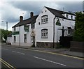
The Forge Inn, Glenfield
Public House along Main Street.
Image: © Mat Fascione
Taken: 7 Jul 2007
0.20 miles