IMAGES TAKEN NEAR TO
Waring Close, LEICESTER, LE3 8PZ
Introduction
This page details the photographs taken nearby to Waring Close, LE3 8PZ by members of the Geograph project.
The Geograph project started in 2005 with the aim of publishing, organising and preserving representative images for every square kilometre of Great Britain, Ireland and the Isle of Man.

There are currently over 7.5m images from over14,400 individuals and you can help contribute to the project by visiting https://www.geograph.org.uk
Image Map (Loading...)


Getting Data...Please wait
Leaflet Map data © OpenStreetMap
Images are licensed for reuse under creativecommons.org/licenses/by-sa/2.0
Notes
- Clicking on the map will re-center to the selected point.
- The higher the marker number, the further away the image location is from the centre of the postcode.
Image Listing (9 Images Found)
Images are licensed for reuse under creativecommons.org/licenses/by-sa/2.0
Image
Details
Distance

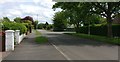
2

Fairefield Crescent, Glenfield
This is just a few metres outside the Leicester City boundary, and is definitely a "well heeled" area.
Image: © John Welford
Taken: 5 Jul 2016
0.14 miles
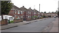
3
Battersbee Road in New Parks, Leicester
Image: © Mat Fascione
Taken: 27 Dec 2016
0.19 miles
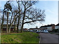
5
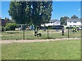
Play space and outdoor gym
In a corner of Holmwood Drive Open Space.
Image: © Ian Calderwood
Taken: 7 Jul 2023
0.23 miles
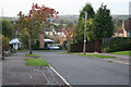
6
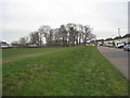
Bird's Nest
The large building behind the trees is New Parks Social Club and the street is Battersbee Road.
Image: © Jonathan Thacker
Taken: 4 Feb 2012
0.23 miles