IMAGES TAKEN NEAR TO
Tatlow Road, LEICESTER, LE3 8ND
Introduction
This page details the photographs taken nearby to Tatlow Road, LE3 8ND by members of the Geograph project.
The Geograph project started in 2005 with the aim of publishing, organising and preserving representative images for every square kilometre of Great Britain, Ireland and the Isle of Man.

There are currently over 7.5m images from over14,400 individuals and you can help contribute to the project by visiting https://www.geograph.org.uk
Image Map (11 Images)


Getting Data...Please wait
Leaflet Map data © OpenStreetMap
Images are licensed for reuse under creativecommons.org/licenses/by-sa/2.0
Notes
- Clicking on the map will re-center to the selected point.
- The higher the marker number, the further away the image location is from the centre of the postcode.
Image Listing (11 Images Found)
Images are licensed for reuse under creativecommons.org/licenses/by-sa/2.0
Image
Details
Distance

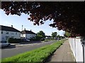
5
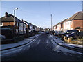
Pennant Close
Taken from the end of the cul de sac looking towards the junction with Tournament Road
Image: © Tim Glover
Taken: 13 Jan 2013
0.13 miles
6

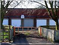
Tatlow Road sign
The road sign is bolted to the spiked fence surrounding the grounds of Braunstone Frith Infant and Junior Schools of which some buildings are to be seen. Other schools quite near to this one have fences twice as high!
Image: © Andrew Tatlow
Taken: 13 Mar 2007
0.14 miles

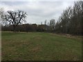
10
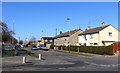
Green space along Ryder Road in Braunstone Frith
Image: © Mat Fascione
Taken: 26 Apr 2017
0.23 miles