IMAGES TAKEN NEAR TO
Redfern Close, LEICESTER, LE3 8JQ
Introduction
This page details the photographs taken nearby to Redfern Close, LE3 8JQ by members of the Geograph project.
The Geograph project started in 2005 with the aim of publishing, organising and preserving representative images for every square kilometre of Great Britain, Ireland and the Isle of Man.

There are currently over 7.5m images from over14,400 individuals and you can help contribute to the project by visiting https://www.geograph.org.uk
Image Map (Loading...)


Getting Data...Please wait
Leaflet Map data © OpenStreetMap
Images are licensed for reuse under creativecommons.org/licenses/by-sa/2.0
Notes
- Clicking on the map will re-center to the selected point.
- The higher the marker number, the further away the image location is from the centre of the postcode.
Image Listing (17 Images Found)
Images are licensed for reuse under creativecommons.org/licenses/by-sa/2.0
Image
Details
Distance
2
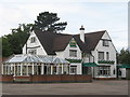
Groby Brant Inn
Leicester Road. Extensive Everards pub/hotel/restaurant.
Image: © the bitterman
Taken: 19 Sep 2010
0.07 miles
3

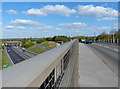
Path along Leicester Road in Groby
Up ahead is the bridge crossing over the A46.
Image: © Mat Fascione
Taken: 15 Apr 2014
0.09 miles
4

Sliproad from the A46
Leading to the A50.
Image: © Mat Fascione
Taken: 4 Jun 2012
0.15 miles

6
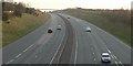
The A46 curves away to the south-west
Photographed from close to the A50/A46 roundabout in Leicester.
Image: © Mat Fascione
Taken: 1 Apr 2007
0.16 miles

9
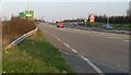
Looking along the A50 towards the roundabout with the A46 in Leicester.
Image: © Mat Fascione
Taken: 1 Apr 2007
0.18 miles
10
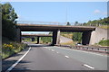
A46 bridges of A50 junction roundabout
Image: © J.Hannan-Briggs
Taken: 18 Jul 2015
0.21 miles