IMAGES TAKEN NEAR TO
Leicester Road, LEICESTER, LE3 8HD
Introduction
This page details the photographs taken nearby to Leicester Road, LE3 8HD by members of the Geograph project.
The Geograph project started in 2005 with the aim of publishing, organising and preserving representative images for every square kilometre of Great Britain, Ireland and the Isle of Man.

There are currently over 7.5m images from over14,400 individuals and you can help contribute to the project by visiting https://www.geograph.org.uk
Image Map (Loading...)


Getting Data...Please wait
Leaflet Map data © OpenStreetMap
Images are licensed for reuse under creativecommons.org/licenses/by-sa/2.0
Notes
- Clicking on the map will re-center to the selected point.
- The higher the marker number, the further away the image location is from the centre of the postcode.
Image Listing (19 Images Found)
Images are licensed for reuse under creativecommons.org/licenses/by-sa/2.0
Image
Details
Distance
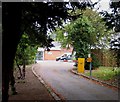
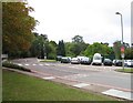
1
Leicestershire Fire and Rescue Headquarters
Image: © Andrew Tatlow
Taken: 3 Sep 2011
0.01 miles
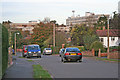
2
Leicestershire Fire and Rescue Headquarters
Image: © Andrew Tatlow
Taken: 3 Sep 2011
0.05 miles
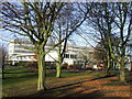
3
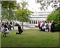
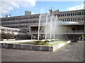
Wedding photographs at County Hall
The registry office is in the background.
Image: © Andrew Tatlow
Taken: 3 Sep 2011
0.05 miles
4
Leicestershire Registration Service at County Hall
Image: © Andrew Tatlow
Taken: 3 Sep 2011
0.06 miles
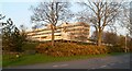
6
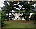
County Hall, Glenfield, Leicester
Right in the NE corner of the square, County Hall is on Leicester Road. The photograph was taken from Faire Road.
Image: © Kate Jewell
Taken: 7 Nov 2005
0.10 miles
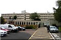
8

Leicestershire County Council
This is County Hall in Glenfield.
Image: © Mat Fascione
Taken: 19 Jan 2014
0.11 miles
9
County Hall, Glenfield.
Photographed from the opposite side of the A50 Groby Road in Glenfield, Leicester.
Image: © Mat Fascione
Taken: 1 Apr 2007
0.12 miles
10
County Hall, Glenfield, Leicester
The HQ of Leicestershire County Council.
Image: © Colin Hoskins
Taken: 31 Mar 2009
0.12 miles