IMAGES TAKEN NEAR TO
Faire Road, LEICESTER, LE3 8EF
Introduction
This page details the photographs taken nearby to Faire Road, LE3 8EF by members of the Geograph project.
The Geograph project started in 2005 with the aim of publishing, organising and preserving representative images for every square kilometre of Great Britain, Ireland and the Isle of Man.

There are currently over 7.5m images from over14,400 individuals and you can help contribute to the project by visiting https://www.geograph.org.uk
Image Map
Images are licensed for reuse under creativecommons.org/licenses/by-sa/2.0
Notes
- Clicking on the map will re-center to the selected point.
- The higher the marker number, the further away the image location is from the centre of the postcode.
Image Listing (19 Images Found)
Images are licensed for reuse under creativecommons.org/licenses/by-sa/2.0
Image
Details
Distance
1
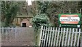
West portal of the Glenfield Tunnel
When it opened in 1832, the Glenfield Tunnel was the longest steam railway tunnel in the world. It is just over one mile long and was designed by the railway engineer George Stephenson. It formed part of the Leicester and Swannington Railway. When the railway closed in the 1960s, the redundant tunnel was bought by Leicester City Council for £5. In 2008 the tunnel underwent a £500,000 retrofit to install strengthening rings to prevent a collapse of the tunnel shaft. This is the western portal of the tunnel, located at the end of Stephenson Court.
Image: © Mat Fascione
Taken: 19 Feb 2020
0.07 miles
2
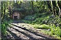
Glenfield Railway Tunnel
A fence prevents any closer access to this famous structure. The other portal has been buried. http://www.forgottenrelics.co.uk/tunnels/glenfield.html
Image: © Ashley Dace
Taken: 29 Apr 2012
0.09 miles
3

Glenfield Railway Tunnel
A fence prevents any closer access to this famous structure. The other portal has been buried. http://www.forgottenrelics.co.uk/tunnels/glenfield.html
Image: © Ashley Dace
Taken: 29 Apr 2012
0.12 miles
4
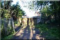
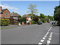
Site of the former Leicester to Swannington Railway
Behind me is the tunnel, housing on Stephenson's way now takes its place.
Image: © Ashley Dace
Taken: 29 Apr 2012
0.13 miles
7

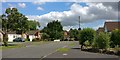
Field Gate Gardens
Entrance to a gated road off Station Road, Glenfield
Image: © John Welford
Taken: 19 Jan 2016
0.18 miles
8
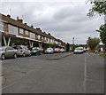
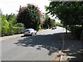
Faire Road
The A50 dual carriageway lies at the end of the road, with County Hall's grounds beyond.
Image: © Peter Whatley
Taken: 7 May 2009
0.19 miles