IMAGES TAKEN NEAR TO
Dominion Road, LEICESTER, LE3 6QD
Introduction
This page details the photographs taken nearby to Dominion Road, LE3 6QD by members of the Geograph project.
The Geograph project started in 2005 with the aim of publishing, organising and preserving representative images for every square kilometre of Great Britain, Ireland and the Isle of Man.

There are currently over 7.5m images from over14,400 individuals and you can help contribute to the project by visiting https://www.geograph.org.uk
Image Map
Images are licensed for reuse under creativecommons.org/licenses/by-sa/2.0
Notes
- Clicking on the map will re-center to the selected point.
- The higher the marker number, the further away the image location is from the centre of the postcode.
Image Listing (14 Images Found)
Images are licensed for reuse under creativecommons.org/licenses/by-sa/2.0
Image
Details
Distance
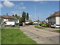
1
Dominion Road, New Parks
Looking towards Glenfield.
Image: © Richard Vince
Taken: 16 Oct 2018
0.05 miles
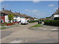
2
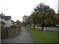
Footpath along Charnor Road, New Parks
Seen from Dominion Road.
Image: © Richard Vince
Taken: 16 Oct 2018
0.06 miles
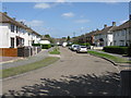
3
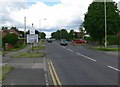
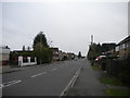
Welcome to Glenfield
Looking west along Dominion Road.
Image: © Mat Fascione
Taken: 7 Jul 2007
0.07 miles
4
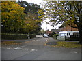
Knowles Road, New Parks
Off Charnor Road.
Image: © Richard Vince
Taken: 16 Oct 2018
0.09 miles
5
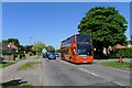
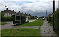
First Leicester bus service 14
Frequent service from New Parks to St Margarets Bus Station
Image: © Tim Heaton
Taken: 3 Jun 2023
0.12 miles
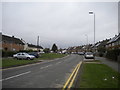
7
Liberty Road, Glenfield
Looking towards Kirby Frith from Dominion Road.
Image: © Richard Vince
Taken: 16 Oct 2018
0.18 miles