IMAGES TAKEN NEAR TO
Letchworth Road, LEICESTER, LE3 6FJ
Introduction
This page details the photographs taken nearby to Letchworth Road, LE3 6FJ by members of the Geograph project.
The Geograph project started in 2005 with the aim of publishing, organising and preserving representative images for every square kilometre of Great Britain, Ireland and the Isle of Man.

There are currently over 7.5m images from over14,400 individuals and you can help contribute to the project by visiting https://www.geograph.org.uk
Image Map
Images are licensed for reuse under creativecommons.org/licenses/by-sa/2.0
Notes
- Clicking on the map will re-center to the selected point.
- The higher the marker number, the further away the image location is from the centre of the postcode.
Image Listing (10 Images Found)
Images are licensed for reuse under creativecommons.org/licenses/by-sa/2.0
Image
Details
Distance
1
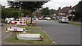
Letchworth Road, Leicester
Lots of work is being done on the gas mains!
Image: © John Welford
Taken: 9 Sep 2015
0.04 miles
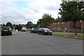
2
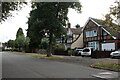
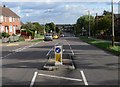
Letchworth Road, Leicester
This could easily be anywhere around Harrow as well.
Image: © David Howard
Taken: 2 Aug 2022
0.06 miles
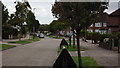

7
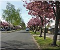
Blossom trees along Glenfield Road, Leicester
Image: © Mat Fascione
Taken: 15 Apr 2020
0.17 miles
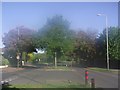
8
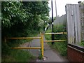
Footpath from Piper Way to Glenfield Road
The entrance to the footpath off Piper Way. Note the anti-cycling barriers.
Image: © David P Howard
Taken: 15 Jun 2010
0.19 miles
9
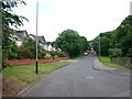
Junction of Piper Way and Piper Close
View NE up Piper Way.
Image: © David P Howard
Taken: 15 Jun 2010
0.21 miles
10
Aikman Avenue in New Parks
At the junction with Adcock Road.
Image: © Mat Fascione
Taken: 25 Sep 2010
0.23 miles