IMAGES TAKEN NEAR TO
Fitzroy Street, LEICESTER, LE3 5PQ
Introduction
This page details the photographs taken nearby to Fitzroy Street, LE3 5PQ by members of the Geograph project.
The Geograph project started in 2005 with the aim of publishing, organising and preserving representative images for every square kilometre of Great Britain, Ireland and the Isle of Man.

There are currently over 7.5m images from over14,400 individuals and you can help contribute to the project by visiting https://www.geograph.org.uk
Image Map (Loading...)


Getting Data...Please wait
Leaflet Map data © OpenStreetMap
Images are licensed for reuse under creativecommons.org/licenses/by-sa/2.0
Notes
- Clicking on the map will re-center to the selected point.
- The higher the marker number, the further away the image location is from the centre of the postcode.
Image Listing (250 Images Found)
Images are licensed for reuse under creativecommons.org/licenses/by-sa/2.0
Image
Details
Distance
3
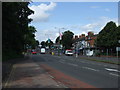
King Richards Road, Leicester
Looking back towards Leicester city centre.
Image: © Mat Fascione
Taken: 7 Jul 2007
0.03 miles
5
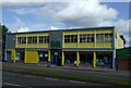
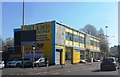
Furniture Store, King Richards Road, Leicester
Image: © JThomas
Taken: 4 Aug 2012
0.04 miles
6
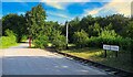
West Bridge station
Leicester's first railway station
Image: © Robert Murray
Taken: 8 Aug 2020
0.05 miles
7

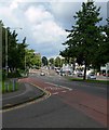
St Augustines Road at the junction of Narborough Road North
Image: © David Howard
Taken: 20 Sep 2020
0.07 miles
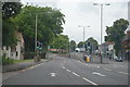
8

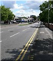
St Augustines Road, Leicester
The green is the middle of the dual carriageway
Image: © David Howard
Taken: 20 Sep 2020
0.08 miles
10
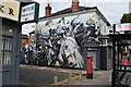
Mural, King Richards Road
On the corner of Kate Street
Image: © Keith Edkins
Taken: 24 Jul 2023
0.09 miles