IMAGES TAKEN NEAR TO
Catesby Street, LEICESTER, LE3 5PB
Introduction
This page details the photographs taken nearby to Catesby Street, LE3 5PB by members of the Geograph project.
The Geograph project started in 2005 with the aim of publishing, organising and preserving representative images for every square kilometre of Great Britain, Ireland and the Isle of Man.

There are currently over 7.5m images from over14,400 individuals and you can help contribute to the project by visiting https://www.geograph.org.uk
Image Map (Loading...)


Getting Data...Please wait
Leaflet Map data © OpenStreetMap
Images are licensed for reuse under creativecommons.org/licenses/by-sa/2.0
Notes
- Clicking on the map will re-center to the selected point.
- The higher the marker number, the further away the image location is from the centre of the postcode.
Image Listing (60 Images Found)
Images are licensed for reuse under creativecommons.org/licenses/by-sa/2.0
Image
Details
Distance
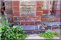
1
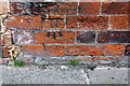
Benchmark on #101 Hinckley Road, Norfolk Street face
Ordnance Survey cut mark benchmark described on the Bench Mark Database at https://www.bench-marks.org.uk/bm102383
Image: © Roger Templeman
Taken: 11 May 2018
0.06 miles
2
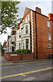
Hinckley Road houses at Norfolk Street junction
There is an OS benchmark Image on the side of the nearest house at its junction with its front garden side wall, left of the black downpipe
Image: © Roger Templeman
Taken: 11 May 2018
0.06 miles
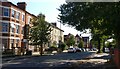
4
Fosse Road Central in Leicester
In the Westcotes area of Leicester.
Image: © Mat Fascione
Taken: 2 Oct 2019
0.10 miles
5
Fosse Road Central in Leicester
In the Westcotes area of Leicester.
Image: © Mat Fascione
Taken: 2 Oct 2019
0.10 miles
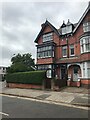
7
#15 Fosse Road Central
There is an OS benchmark Image on the wall pier at the centre of the image
Image: © Roger Templeman
Taken: 11 May 2018
0.12 miles
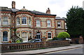
8
Benchmark on wall pier outside #15 Fosse Road Central
Ordnance Survey cut mark benchmark described on the Bench Mark Database at https://www.bench-marks.org.uk/bm102381
Image: © Roger Templeman
Taken: 11 May 2018
0.12 miles
9
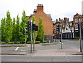
Junction of Hinckley Road and Narborough Road North
There used to be a bank on the corner which was demolished when the road was widened. There was also a pub opposite, see https://www.bench-marks.org.uk/bm22268
Image: © Roger Templeman
Taken: 11 May 2018
0.13 miles
10
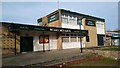
Merry Monarch pub
Modern looking pub in Westcotes.
Image: © Pierre Marshall
Taken: 7 Nov 2020
0.13 miles