IMAGES TAKEN NEAR TO
All Saints Road, LEICESTER, LE3 5FH
Introduction
This page details the photographs taken nearby to All Saints Road, LE3 5FH by members of the Geograph project.
The Geograph project started in 2005 with the aim of publishing, organising and preserving representative images for every square kilometre of Great Britain, Ireland and the Isle of Man.

There are currently over 7.5m images from over14,400 individuals and you can help contribute to the project by visiting https://www.geograph.org.uk
Image Map
Images are licensed for reuse under creativecommons.org/licenses/by-sa/2.0
Notes
- Clicking on the map will re-center to the selected point.
- The higher the marker number, the further away the image location is from the centre of the postcode.
Image Listing (559 Images Found)
Images are licensed for reuse under creativecommons.org/licenses/by-sa/2.0
Image
Details
Distance
1
All Saints Road in Leicester
The run down Black Friars area of Leicester, currently being redeveloped.
Image: © Mat Fascione
Taken: 8 Dec 2019
0.01 miles
2
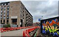
The Arches Apartments on All Saints Road
Part of the wider regeneration of the Black Friars area of Leicester.
Image: © Mat Fascione
Taken: 28 Oct 2021
0.02 miles
3

The former Great Central Railway Leicester Central Station
The old railway station that is now an industrial estate. Image
The canopy and platforms were sited to the left where the units are now. The car park to the right was the site of the turn table.
Image: © Ashley Dace
Taken: 17 Oct 2010
0.03 miles
4
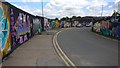
All Saints Road in Leicester
Part of the regeneration of the Black Friars area of Leicester.
Image, same view taken over 5 months later.
Image: © Mat Fascione
Taken: 27 Jan 2019
0.03 miles
5
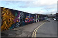
Graffiti along All Saints Road in Leicester
The regeneration of the Black Friars area of Leicester.
Image, same view without the graffiti, taken over 5 months earlier.
Image: © Mat Fascione
Taken: 1 Jul 2019
0.03 miles
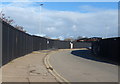
6

Viaduct of the former Great Central Railway
The bridge taking the Great Central railway across a small road. The viaduct now hosts an industrial estate.
Image: © Ashley Dace
Taken: 17 Oct 2010
0.04 miles
7
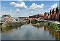
Grand Union Canal in Black Friars, Leicester
The apartments on the right are on Grand Union Embankment.
Black Friars is an area of Leicester, about half a mile west of Leicester city centre, it is named after a former Dominican Friary which was in the area. It lies next to the River Soar and is undergoing redevelopment.
Image: © Mat Fascione
Taken: 5 May 2024
0.04 miles
8
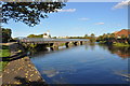
Bridge over the Canal
A bridge runs over the canal.
Image: © Ashley Dace
Taken: 17 Oct 2010
0.04 miles
9
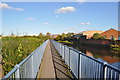
Footbridge belong the canal
The navigable section continues straight on while another flow continues left.
Image: © Ashley Dace
Taken: 17 Oct 2010
0.04 miles
10
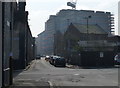
Jarvis Street in Black Friars, Leicester
Image: © Mat Fascione
Taken: 13 Mar 2016
0.04 miles