IMAGES TAKEN NEAR TO
Tuffleys Way, LEICESTER, LE3 3UT
Introduction
This page details the photographs taken nearby to Tuffleys Way, LE3 3UT by members of the Geograph project.
The Geograph project started in 2005 with the aim of publishing, organising and preserving representative images for every square kilometre of Great Britain, Ireland and the Isle of Man.

There are currently over 7.5m images from over14,400 individuals and you can help contribute to the project by visiting https://www.geograph.org.uk
Image Map (Loading...)


Getting Data...Please wait
Leaflet Map data © OpenStreetMap
Images are licensed for reuse under creativecommons.org/licenses/by-sa/2.0
Notes
- Clicking on the map will re-center to the selected point.
- The higher the marker number, the further away the image location is from the centre of the postcode.
Image Listing (62 Images Found)
Images are licensed for reuse under creativecommons.org/licenses/by-sa/2.0
Image
Details
Distance
1
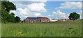
Thorpe Astley, Leicester
This is the westernmost edge of the new Thorpe Astley housing estate, sadly this field will probably be built over in the next couple of years. A public footpath runs along the left edge of the photo.
Image: © Mat Fascione
Taken: 5 Jun 2007
0.03 miles
2
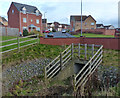
Tuffleys Way bridge in Thorpe Astley
Crossing Lubbesthorpe Brook.
Image: © Mat Fascione
Taken: 19 Jan 2014
0.04 miles
3
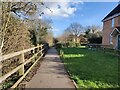
Path to Tuffleys Way at Thorpe Astley
Thorpe Astley is a housing estate and suburb on the western edge of Leicester.
Image: © Mat Fascione
Taken: 12 Feb 2024
0.05 miles
4
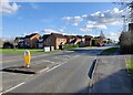
Murby Way in Thorpe Astley
Thorpe Astley is a housing estate and suburb on the western edge of Leicester.
Image: © Mat Fascione
Taken: 12 Feb 2024
0.08 miles
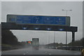
6
M1 southbound approaching Junction 21
Image: © J.Hannan-Briggs
Taken: 18 Jul 2015
0.14 miles
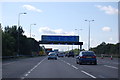
7

M1 Motorway traffic from the north
The exit road from Leicester Forest East Service Area is to the right.
Image: © Andrew Tatlow
Taken: 7 May 2018
0.14 miles
8
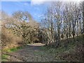
Woodland and path next to M1 motorway
At Thorpe Astley on the western edge of Leicester.
Image: © Mat Fascione
Taken: 12 Feb 2024
0.14 miles
9
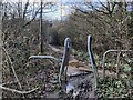
Path to Leicester Forest East
At Thorpe Astley on the western edge of Leicester. The path is about to pass under the M1 motorway.
Image: © Mat Fascione
Taken: 12 Feb 2024
0.15 miles