IMAGES TAKEN NEAR TO
Grange Avenue, LEICESTER, LE3 3HR
Introduction
This page details the photographs taken nearby to Grange Avenue, LE3 3HR by members of the Geograph project.
The Geograph project started in 2005 with the aim of publishing, organising and preserving representative images for every square kilometre of Great Britain, Ireland and the Isle of Man.

There are currently over 7.5m images from over14,400 individuals and you can help contribute to the project by visiting https://www.geograph.org.uk
Image Map (Loading...)


Getting Data...Please wait
Leaflet Map data © OpenStreetMap
Images are licensed for reuse under creativecommons.org/licenses/by-sa/2.0
Notes
- Clicking on the map will re-center to the selected point.
- The higher the marker number, the further away the image location is from the centre of the postcode.
Image Listing (29 Images Found)
Images are licensed for reuse under creativecommons.org/licenses/by-sa/2.0
Image
Details
Distance
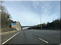
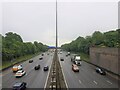
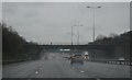
2
The M1 Motorway
Looking southeast from the A47 Hinckley Road Bridge, Leicester Forest East.
Image: © Mat Fascione
Taken: 1 May 2007
0.04 miles
4
A47 Hinckley Road crossing the M1 motorway
Image: © Mat Fascione
Taken: 1 Jun 2014
0.05 miles
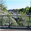
5
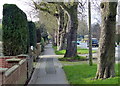
Trees and path along Hinckley Road
In the Leicester Forest East area of Leicester.
Image: © Mat Fascione
Taken: 16 Jan 2016
0.05 miles
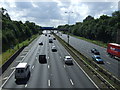
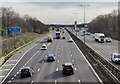
7
The M1 passing the west side of Leicester
Seen from the Hinkley Road (A47) bridge
Image: © Tim Heaton
Taken: 1 Jun 2022
0.06 miles
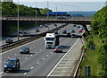
8
M1 motorway towards the Leicester Forest East Services
Image: © Mat Fascione
Taken: 20 Feb 2024
0.07 miles
10
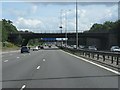
M1 motorway - A47 bridge, Leicester Forest East
Image: © Peter Whatley
Taken: 28 Jul 2013
0.08 miles