IMAGES TAKEN NEAR TO
Galahad Close, LEICESTER, LE3 3EX
Introduction
This page details the photographs taken nearby to Galahad Close, LE3 3EX by members of the Geograph project.
The Geograph project started in 2005 with the aim of publishing, organising and preserving representative images for every square kilometre of Great Britain, Ireland and the Isle of Man.

There are currently over 7.5m images from over14,400 individuals and you can help contribute to the project by visiting https://www.geograph.org.uk
Image Map (Loading...)


Getting Data...Please wait
Leaflet Map data © OpenStreetMap
Images are licensed for reuse under creativecommons.org/licenses/by-sa/2.0
Notes
- Clicking on the map will re-center to the selected point.
- The higher the marker number, the further away the image location is from the centre of the postcode.
Image Listing (11 Images Found)
Images are licensed for reuse under creativecommons.org/licenses/by-sa/2.0
Image
Details
Distance
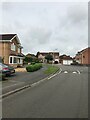
4
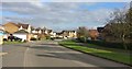
Houses on Forest House Lane
The houses and farmland are on the edge of Leicester Forest East, on the western edge of Leicester city.
Image: © Mat Fascione
Taken: 19 Jan 2014
0.17 miles
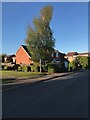
5
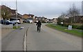
Forest House Lane at Leicester Forest East
Image: © Mat Fascione
Taken: 8 Feb 2017
0.18 miles
6
Forest House Lane at Leicester Forest East
Image: © Mat Fascione
Taken: 10 Nov 2017
0.19 miles
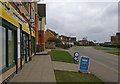
7
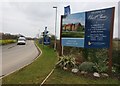
Welcome to Forest Chase
Forest Chase is a new housing development in Leicester Forest East, on the edge of Leicester.
Image: © Mat Fascione
Taken: 9 Feb 2017
0.22 miles
8

Footbridge near Old Warren Farm
Looking east towards the Leicester city skyline.
This view will be very different in the years to come, as this is the site of the proposed New Lubbesthorpe housing development, 4,250 homes will be built on a site that lies to the west of the M1, east of Beggar’s Lane, south of Leicester Forest East and north and south of the M69.
Image: © Mat Fascione
Taken: 19 Jan 2014
0.23 miles
9

Path to Forest House Lane
In Leicester Forest East, on the western edge of Leicester.
Image: © Mat Fascione
Taken: 10 Nov 2017
0.25 miles
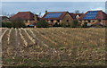
10
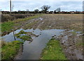
Muddy farmland on the edge of Leicester Forest East
Image: © Mat Fascione
Taken: 19 Jan 2014
0.25 miles