IMAGES TAKEN NEAR TO
Valley Drive, LEICESTER, LE3 3ED
Introduction
This page details the photographs taken nearby to Valley Drive, LE3 3ED by members of the Geograph project.
The Geograph project started in 2005 with the aim of publishing, organising and preserving representative images for every square kilometre of Great Britain, Ireland and the Isle of Man.

There are currently over 7.5m images from over14,400 individuals and you can help contribute to the project by visiting https://www.geograph.org.uk
Image Map (Loading...)


Getting Data...Please wait
Leaflet Map data © OpenStreetMap
Images are licensed for reuse under creativecommons.org/licenses/by-sa/2.0
Notes
- Clicking on the map will re-center to the selected point.
- The higher the marker number, the further away the image location is from the centre of the postcode.
Image Listing (16 Images Found)
Images are licensed for reuse under creativecommons.org/licenses/by-sa/2.0
Image
Details
Distance
1
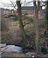
Lubbesthorpe Brook in Braunstone
The houses are on Haskell Close in Thorpe Astley.
Image: © Mat Fascione
Taken: 8 Mar 2017
0.08 miles
2
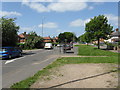
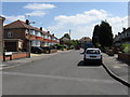
Westover Road - Hardie Crescent Crossroads
Image: © Peter Whatley
Taken: 7 May 2009
0.12 miles
3
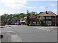
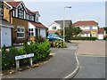
Houses at the Hardie Crescent / Westover Road junction
Image: © Roger Templeman
Taken: 11 Sep 2018
0.13 miles
5
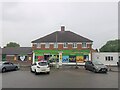
Londis shop, Sun Way, Braunstone, Leicester
Run as franchises; owned by Tescos
Image: © Tim Heaton
Taken: 1 Jun 2022
0.16 miles
7
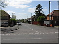
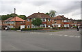
Westover Road
Taken from across Braunstone Lane.
Image: © Peter Whatley
Taken: 7 May 2009
0.17 miles
9
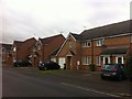
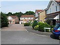
Darien Way
2000s houses in Braunstone.
Image: © Burgess Von Thunen
Taken: 6 Dec 2013
0.21 miles