IMAGES TAKEN NEAR TO
Shottery Avenue, LEICESTER, LE3 2ST
Introduction
This page details the photographs taken nearby to Shottery Avenue, LE3 2ST by members of the Geograph project.
The Geograph project started in 2005 with the aim of publishing, organising and preserving representative images for every square kilometre of Great Britain, Ireland and the Isle of Man.

There are currently over 7.5m images from over14,400 individuals and you can help contribute to the project by visiting https://www.geograph.org.uk
Image Map (Loading...)


Getting Data...Please wait
Leaflet Map data © OpenStreetMap
Images are licensed for reuse under creativecommons.org/licenses/by-sa/2.0
Notes
- Clicking on the map will re-center to the selected point.
- The higher the marker number, the further away the image location is from the centre of the postcode.
Image Listing (62 Images Found)
Images are licensed for reuse under creativecommons.org/licenses/by-sa/2.0
Image
Details
Distance
2
Jubilee bunting on Shakespeare Drive, Braunstone
Image: © Mat Fascione
Taken: 31 May 2022
0.10 miles
4
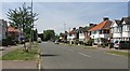
Shakespeare Drive in Braunstone, Leicester
Image: © Mat Fascione
Taken: 18 Jul 2017
0.11 miles
6

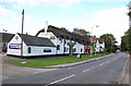
Leicester, LE3 - Old Braunston
The rear of The Shakespeare public house, complete with a beacon in the car park. Shakespeare Park is situated immediately behind the photographer. These premises were part of a farm (Ashleigh Farm) until 1938, worked by a tenant but owned - until the early 1950's - by a Mr Shakespeare, the senior partner of Shakespeare, McTurk & Graham, Leicester auctioneers. The premises opened as The Shakespeare Inn in 1954 having been duly converted. The farm buildings and ponds that previously occupied the site were levelled to create the car park.
Image: © David Hallam-Jones
Taken: 1 Jul 2012
0.12 miles
8
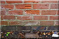
Benchmark on #267 Braunstone Avenue
Ordnance Survey cut mark benchmark described on the Bench Mark Database at www.bench-marks.org.uk/bm99529
Image: © Roger Templeman
Taken: 11 Sep 2018
0.12 miles
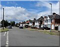
9
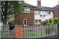
Nos. 267 and 265 Braunstone Avenue
There is an OS benchmark Image on the outbuilding at the end of the side path of the left hand house
Image: © Roger Templeman
Taken: 11 Sep 2018
0.13 miles
10
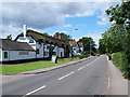
Leicester, LE3 - Old Braunstone
The Shakespeare public house on Main Street with Narborough Road and access to Leicester behind the photographer. These premises were part of a farm (Ashleigh Farm) until 1938, worked by a tenant but owned - until the early 1950's - by a Mr Shakespeare, the senior partner of Shakespeare, McTurk & Graham, Leicester auctioneers. The premises opened as The Shakespeare Inn in 1954 having been duly converted. The farm buildings and ponds that previously occupied the site were levelled to create the present car park. A brick dated "1655" has been identified within its structure.
Image: © David Hallam-Jones
Taken: 1 Jul 2012
0.14 miles