IMAGES TAKEN NEAR TO
Arden Avenue, LEICESTER, LE3 2SG
Introduction
This page details the photographs taken nearby to Arden Avenue, LE3 2SG by members of the Geograph project.
The Geograph project started in 2005 with the aim of publishing, organising and preserving representative images for every square kilometre of Great Britain, Ireland and the Isle of Man.

There are currently over 7.5m images from over14,400 individuals and you can help contribute to the project by visiting https://www.geograph.org.uk
Image Map
Images are licensed for reuse under creativecommons.org/licenses/by-sa/2.0
Notes
- Clicking on the map will re-center to the selected point.
- The higher the marker number, the further away the image location is from the centre of the postcode.
Image Listing (55 Images Found)
Images are licensed for reuse under creativecommons.org/licenses/by-sa/2.0
Image
Details
Distance
4
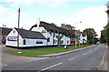
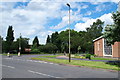
Braunstone Lane, Leicester
Looking towards Hallam Crescent East
Image: © David Howard
Taken: 2 Aug 2022
0.13 miles
5
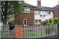
Nos. 267 and 265 Braunstone Avenue
There is an OS benchmark Image on the outbuilding at the end of the side path of the left hand house
Image: © Roger Templeman
Taken: 11 Sep 2018
0.14 miles
6
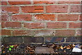
Benchmark on #267 Braunstone Avenue
Ordnance Survey cut mark benchmark described on the Bench Mark Database at www.bench-marks.org.uk/bm99529
Image: © Roger Templeman
Taken: 11 Sep 2018
0.14 miles
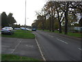
7
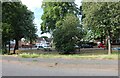
Leicester, LE3 - Braunston
Braunstone Baptist Church and one of the entrances to Braunstone Park (just visible behind the left bollard) are two of the features of this junction of Braunstone Road and Hallam Crescent East. Braunstone Police Station is situated immediately behind the photographer.
Image: © David Hallam-Jones
Taken: 1 Jul 2012
0.15 miles
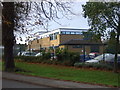
8
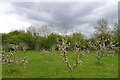
Community Orchard, Franklin Park, Braunstone Town
"The community orchard is a great place to pick apples, pears, blackberries, and even quinces, when they're in season!" https://www.braunstonetowncouncil.org.uk/index.php/parks-openspaces/parks/franklin-park
Image: © Tim Heaton
Taken: 5 May 2021
0.15 miles
9
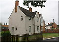
#191 Hallam Crescent East and #111 Waltham Avenue
Ordnance Survey documents indicate that in 1964 there was a cut mark benchmark levelled at 73.344m above Newlyn Datum on the near corner of the left hand house which has been pebbledashed hiding the mark.
Image: © Roger Templeman
Taken: 11 Sep 2018
0.15 miles