IMAGES TAKEN NEAR TO
Braunstone Close, LEICESTER, LE3 2GW
Introduction
This page details the photographs taken nearby to Braunstone Close, LE3 2GW by members of the Geograph project.
The Geograph project started in 2005 with the aim of publishing, organising and preserving representative images for every square kilometre of Great Britain, Ireland and the Isle of Man.

There are currently over 7.5m images from over14,400 individuals and you can help contribute to the project by visiting https://www.geograph.org.uk
Image Map (Loading...)


Getting Data...Please wait
Leaflet Map data © OpenStreetMap
Images are licensed for reuse under creativecommons.org/licenses/by-sa/2.0
Notes
- Clicking on the map will re-center to the selected point.
- The higher the marker number, the further away the image location is from the centre of the postcode.
Image Listing (25 Images Found)
Images are licensed for reuse under creativecommons.org/licenses/by-sa/2.0
Image
Details
Distance

3
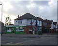
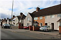
Nos. 83-89 (odds) Braunstone Lane
Ordnance Survey documents indicate that in 1964 there was a cut mark benchmark levelled at 71.576m above Newlyn Datum on the side of the left hand house, which has been pebbledashed with loss of the mark
Image: © Roger Templeman
Taken: 11 Sep 2018
0.08 miles
4
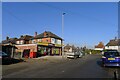
Convenience store, Ayston Road, Leicester
Premier stores "are locally owned by independent retailers", under franchise from the Booker Group, which is a subsidiary of Tescos.
Image: © Tim Heaton
Taken: 26 Jan 2022
0.08 miles
5
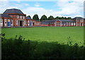
Leicester, LE3 - Braunstone
Caldecote Community Primary School and its playing field, as seen from Braunstone Lane.
Image: © David Hallam-Jones
Taken: 1 Jul 2012
0.11 miles
7
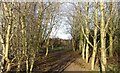
Small patch of woodland at Franklin Park
Image: © Mat Fascione
Taken: 22 Dec 2017
0.15 miles
9
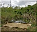
Small pond in Franklin Park, Braunstone
Image: © Mat Fascione
Taken: 13 Apr 2017
0.15 miles
10

Caldecote Community Primary School
Ordnance Survey documents indicate that in 1964 there was a cut mark benchmark levelled at 72.131m above Newlyn Datum on this school
Image: © Roger Templeman
Taken: 11 Sep 2018
0.15 miles