IMAGES TAKEN NEAR TO
Dorchester Road, LEICESTER, LE3 0UJ
Introduction
This page details the photographs taken nearby to Dorchester Road, LE3 0UJ by members of the Geograph project.
The Geograph project started in 2005 with the aim of publishing, organising and preserving representative images for every square kilometre of Great Britain, Ireland and the Isle of Man.

There are currently over 7.5m images from over14,400 individuals and you can help contribute to the project by visiting https://www.geograph.org.uk
Image Map (Loading...)


Getting Data...Please wait
Leaflet Map data © OpenStreetMap
Images are licensed for reuse under creativecommons.org/licenses/by-sa/2.0
Notes
- Clicking on the map will re-center to the selected point.
- The higher the marker number, the further away the image location is from the centre of the postcode.
Image Listing (21 Images Found)
Images are licensed for reuse under creativecommons.org/licenses/by-sa/2.0
Image
Details
Distance
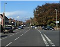
1
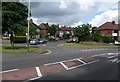
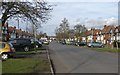
Wyngate Drive, Leicester
Looking across Wyngate Drive to its junction with Dorchester Road.
Image: © Mat Fascione
Taken: 7 Jul 2007
0.05 miles
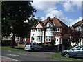
5
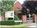
Braunstone Avenue Hall
Evangelical Christian Brethren.
Image: © Mat Fascione
Taken: 7 Jul 2007
0.14 miles
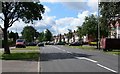
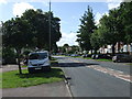
8
Braunstone Avenue Railway Bridge, Leicester
Image: © Mat Fascione
Taken: 7 Jul 2007
0.18 miles
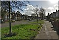
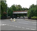
10
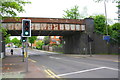
Railway bridge over Braunstone Avenue
There is an OS benchmark Image on the bridge buttress on the right hand side of the road and near side of the railway
Image: © Roger Templeman
Taken: 11 May 2018
0.19 miles