IMAGES TAKEN NEAR TO
Ainsdale Road, LEICESTER, LE3 0UD
Introduction
This page details the photographs taken nearby to Ainsdale Road, LE3 0UD by members of the Geograph project.
The Geograph project started in 2005 with the aim of publishing, organising and preserving representative images for every square kilometre of Great Britain, Ireland and the Isle of Man.

There are currently over 7.5m images from over14,400 individuals and you can help contribute to the project by visiting https://www.geograph.org.uk
Image Map
Images are licensed for reuse under creativecommons.org/licenses/by-sa/2.0
Notes
- Clicking on the map will re-center to the selected point.
- The higher the marker number, the further away the image location is from the centre of the postcode.
Image Listing (29 Images Found)
Images are licensed for reuse under creativecommons.org/licenses/by-sa/2.0
Image
Details
Distance
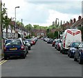
2
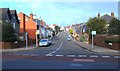
Sunnycroft Road
The junction with the A47 Hinckley Road, Leicester.
Image: © Mat Fascione
Taken: 26 Nov 2008
0.06 miles
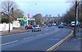
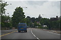
4

A47 Hinckley Road at Western Park, Leicester
Image: © Mat Fascione
Taken: 16 Apr 2020
0.08 miles
5
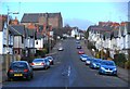
Westfield Road in Leicester
The large building at the top of the hill is St. Annes Parish Church, at the junction of Letchworth Road.
Image: © Mat Fascione
Taken: 26 Nov 2008
0.09 miles
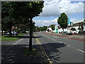
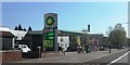
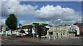
7
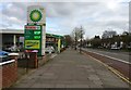
Petrol station along the A47 Hinckley Road
Image: © Mat Fascione
Taken: 17 Feb 2017
0.11 miles