IMAGES TAKEN NEAR TO
Narborough Road, LEICESTER, LE3 0PE
Introduction
This page details the photographs taken nearby to Narborough Road, LE3 0PE by members of the Geograph project.
The Geograph project started in 2005 with the aim of publishing, organising and preserving representative images for every square kilometre of Great Britain, Ireland and the Isle of Man.

There are currently over 7.5m images from over14,400 individuals and you can help contribute to the project by visiting https://www.geograph.org.uk
Image Map (Loading...)


Getting Data...Please wait
Leaflet Map data © OpenStreetMap
Images are licensed for reuse under creativecommons.org/licenses/by-sa/2.0
Notes
- Clicking on the map will re-center to the selected point.
- The higher the marker number, the further away the image location is from the centre of the postcode.
Image Listing (46 Images Found)
Images are licensed for reuse under creativecommons.org/licenses/by-sa/2.0
Image
Details
Distance
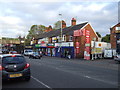
1
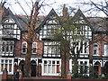
Housing on Narborough Road
Taken morning 25 November 2005 looking west across Narborough Road South near Walton Road.
Image: © Tammy Winand
Taken: 25 Nov 2005
0.02 miles
2
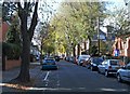
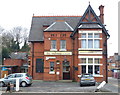
Westcotes Drive, Leicester
On the right is the Church of the Martyrs, close to the junction with Narborough Road.
Image: © Mat Fascione
Taken: 27 Oct 2008
0.04 miles
4
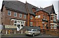
Building work at the Huntsman public house
A new extension has been added to the left side of the pub.
Image
Image: © Mat Fascione
Taken: 10 Jan 2017
0.05 miles
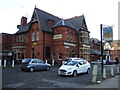
5
The Huntsman public house
Along Narborough Road in Leicester's West End.
Image: © Mat Fascione
Taken: 19 Nov 2014
0.05 miles
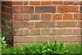
6
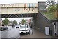
Bridge KSL-5 taking the railway over Narborough Road
There is an OS cut mark benchmark on the right hand bridge wall. The mark is described on the Bench Mark Database at https://www.bench-marks.org.uk/bm67440
Image: © Roger Templeman
Taken: 11 Sep 2018
0.06 miles
7
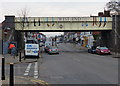
Railway bridge across Narborough Road
The bridge has just been refurbished as part of a £340,000 revamp. The mural was designed by Kieran Stott-Everett, a second-year student at De Montfort University.
It features legs and shoes, and was inspired by Leicester’s historic links with hosiery and shoemaking.
Image: © Mat Fascione
Taken: 19 Nov 2014
0.08 miles
10
Benchmark on Narborough Road college (Noel Street face)
Ordnance Survey cut mark benchmark described on the Bench Mark Database at https://www.bench-marks.org.uk/bm99514
Image: © Roger Templeman
Taken: 11 Sep 2018
0.10 miles