IMAGES TAKEN NEAR TO
Westleigh Avenue, LEICESTER, LE3 0HG
Introduction
This page details the photographs taken nearby to Westleigh Avenue, LE3 0HG by members of the Geograph project.
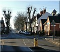
The Geograph project started in 2005 with the aim of publishing, organising and preserving representative images for every square kilometre of Great Britain, Ireland and the Isle of Man.

There are currently over 7.5m images from over14,400 individuals and you can help contribute to the project by visiting https://www.geograph.org.uk
Image Map (Loading...)


Getting Data...Please wait
Leaflet Map data © OpenStreetMap
Images are licensed for reuse under creativecommons.org/licenses/by-sa/2.0
Notes
- Clicking on the map will re-center to the selected point.
- The higher the marker number, the further away the image location is from the centre of the postcode.
Image Listing (58 Images Found)
Images are licensed for reuse under creativecommons.org/licenses/by-sa/2.0
Image
Details
Distance
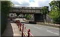
1
Leicester to Burton Railway crosses Fosse Road South
Image: © Tim Glover
Taken: 17 Apr 2011
0.06 miles
2
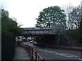
Railway bridge across Fosse Road South
The bridge carries the Leicester to Burton upon Trent freight-only railway line across Fosse Road South, in the Westcotes area of Leicester.
Image: © Mat Fascione
Taken: 18 May 2017
0.08 miles
3
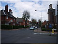
Fosse Road South Leicester
Looking towards railway bridge, Fosse Road South. Holy Apostles Church on the right.
Image: © tony ellis
Taken: 1 May 2008
0.10 miles
4
Fosse Road South in Leicester
At the junction with Winchester Avenue.
Image: © Mat Fascione
Taken: 20 Jan 2017
0.10 miles
5
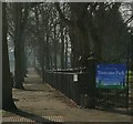
Railings along Westcotes Park
The railings and pavement are along the Canterbury Terrace side of the park.
Image: © Mat Fascione
Taken: 14 Feb 2017
0.11 miles
6
Upperton Road face of #192 Fosse Road South
There is an OS benchmark on the right hand side of the garage just past the gate. A photo showing the mark is not considered suitable for Geograph but is available from the contributor.
Image: © Roger Templeman
Taken: 11 May 2018
0.12 miles
7
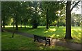
Seat and path at Westcotes Park
This small park is in the Westcotes area of Leicester. It is surrounded by Braunstone Avenue, Winchester Avenue, Canterbury Terrace, and Imperial Avenue.
Image: © Mat Fascione
Taken: 6 Sep 2019
0.12 miles
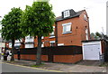
8
#171 Upperton Road at Sykefield Avenue junction
There is an OS benchmark Image on the near corner, right hand face, of the nearest house
Image: © Roger Templeman
Taken: 11 May 2018
0.12 miles
9
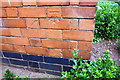
Benchmark on #171 Upperton Road (Sykefield Avenue face)
Ordnance Survey cut mark benchmark described on the Bench Mark Database at https://www.bench-marks.org.uk/bm102481
Image: © Roger Templeman
Taken: 11 May 2018
0.12 miles