IMAGES TAKEN NEAR TO
Western Road, LEICESTER, LE3 0GJ
Introduction
This page details the photographs taken nearby to Western Road, LE3 0GJ by members of the Geograph project.
The Geograph project started in 2005 with the aim of publishing, organising and preserving representative images for every square kilometre of Great Britain, Ireland and the Isle of Man.

There are currently over 7.5m images from over14,400 individuals and you can help contribute to the project by visiting https://www.geograph.org.uk
Image Map (Loading...)


Getting Data...Please wait
Leaflet Map data © OpenStreetMap
Images are licensed for reuse under creativecommons.org/licenses/by-sa/2.0
Notes
- Clicking on the map will re-center to the selected point.
- The higher the marker number, the further away the image location is from the centre of the postcode.
Image Listing (198 Images Found)
Images are licensed for reuse under creativecommons.org/licenses/by-sa/2.0
Image
Details
Distance
2
Grand Union Canal
The old railway bridge took the Great Central railway into the goods yard that was on the right. Housing has been built now.
Image: © Ashley Dace
Taken: 17 Oct 2010
0.04 miles
3
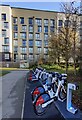
Santander Cycles Leicester
Santander Cycles Leicester is the newest and largest docked e-bike scheme in the UK. It will feature 500 e-bikes at 50 docking stations placed in key locations within the city centre.
This docking station is on Upperton Road.
Image: © Mat Fascione
Taken: 2 Dec 2021
0.04 miles
4
Great Central Way
On the route of the dismantled (closed 1969) Great Central railway. One of the greatest closure mistakes. The housing is sited on the old goods yard, until a couple of years ago I would have passed under a bridge but this was demolished.
The original carriage and wagon works (behind me) is in industrial use.
http://www.gcrleicester.info/html/goods_yard___engine_shed.html
http://www.gcrleicester.info/html/around_leicester.html
Image: © Ashley Dace
Taken: 17 Oct 2010
0.04 miles
5
Upperton Road, Leicester
Here, the Great Central Way crosses Upperton Road at a pelican crossing. The Great Central Way follows the course of a former railway.
Upperton Road used to cross the railway on a viaduct here. The viaduct was demolished in 2007, as it was in poor condition, and the road was lowered to ground level. This may explain why the pavement on the opposite side of the road rises, as if to cross a bridge, then falls. There is more information about the Upperton Road Viaduct, and photos taken before and during demolition, at the GCRLeicester website http://www.gcrleicester.info/html/leicester_demolition_2.html
Image: © Malc McDonald
Taken: 27 Feb 2011
0.04 miles
6
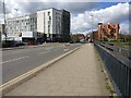
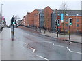
Looking west along Upperton Road, Leicester.
Image: © Mat Fascione
Taken: 1 Apr 2007
0.04 miles
7
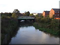
Bridge over the Old River Soar
Disused railway bridge.
Image: © JThomas
Taken: 2 Nov 2013
0.04 miles
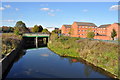
8
Old River Soar in Westcotes, Leicester
Image: © Mat Fascione
Taken: 21 Mar 2017
0.05 miles
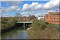
9
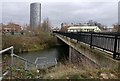
Upperton Road bridge crossing the Old River Soar
The tall building is called The Summit (219 ft), it is student accommodation located along Eastern Boulevard.
Image: © Mat Fascione
Taken: 10 Jan 2017
0.05 miles
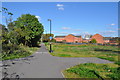
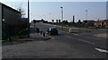
10
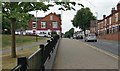
Upperton Road in Westcotes, Leicester
Image: © Mat Fascione
Taken: 19 Jul 2017
0.05 miles