IMAGES TAKEN NEAR TO
Ruding Terrace, LEICESTER, LE3 0BP
Introduction
This page details the photographs taken nearby to Ruding Terrace, LE3 0BP by members of the Geograph project.
The Geograph project started in 2005 with the aim of publishing, organising and preserving representative images for every square kilometre of Great Britain, Ireland and the Isle of Man.

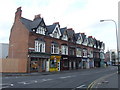
There are currently over 7.5m images from over14,400 individuals and you can help contribute to the project by visiting https://www.geograph.org.uk
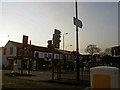
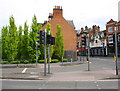
Image Map
Images are licensed for reuse under creativecommons.org/licenses/by-sa/2.0
Notes
- Clicking on the map will re-center to the selected point.
- The higher the marker number, the further away the image location is from the centre of the postcode.
Image Listing (170 Images Found)
Images are licensed for reuse under creativecommons.org/licenses/by-sa/2.0
Image
Details
Distance
1
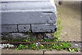
Benchmark on #22A Narborough Road
Ordnance Survey cut mark benchmark described on the Bench Mark Database at https://www.bench-marks.org.uk/bm102475
Image: © Roger Templeman
Taken: 11 May 2018
0.02 miles
2
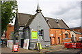
#22A Narborough Road, 'Bed City', at Ruding Road junction
There is an OS benchmark Image on the near corner of the building's jut, right of two wrapped mattresses
Image: © Roger Templeman
Taken: 11 May 2018
0.02 miles
4
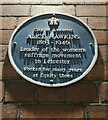
Blue plaque for Alice Hawkins
Alice Hawkins 1863-1946. Leader of the women's suffrage movement in Leicester. Worked for many years at Equity Shoes.
Image
Image: © Mat Fascione
Taken: 9 Dec 2020
0.04 miles
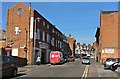
5
Braunstone Gate
A parade of shops at Braunstone Gate in Leicester.
Image: © Malc McDonald
Taken: 26 Feb 2011
0.05 miles
6
Turn left for Hinkley
Near to Leicester city centre.
Image: © Steve Fareham
Taken: 26 Jan 2010
0.07 miles
7
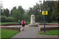
Leicester Marathon, Bede Park
Almost the Loneliness of the Long Distance Runner; this competitor, trailing most of the field, must have been feeling the pain here at the 19 mile mark in Bede Park. A solitary spectator claps some encouragement.
Image: © Stephen McKay
Taken: 14 Oct 2007
0.07 miles
8
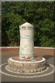
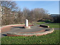
'Making a Place', Bede Park
This curious sculpture, representing a rolled up carpet with a map of Leicester painted around it, was designed by Chloe Cookson and Rory McNally; it was inaugurated in July 2000. It forms a centrepiece for Bede Park, which was formerly an industrial site.
Image: © Stephen McKay
Taken: 14 Oct 2007
0.08 miles
9
Junction of Hinckley Road and Narborough Road North
There used to be a bank on the corner which was demolished when the road was widened. There was also a pub opposite, see https://www.bench-marks.org.uk/bm22268
Image: © Roger Templeman
Taken: 11 May 2018
0.08 miles
10
Bede Park, Leicester
With the sculpture 'Making a Place'. National Cycle route 6 passes through.
Image: © Tim Heaton
Taken: 26 Feb 2012
0.09 miles