IMAGES TAKEN NEAR TO
Howard Road, LEICESTER, LE2 9JH
Introduction
This page details the photographs taken nearby to Howard Road, LE2 9JH by members of the Geograph project.
The Geograph project started in 2005 with the aim of publishing, organising and preserving representative images for every square kilometre of Great Britain, Ireland and the Isle of Man.

There are currently over 7.5m images from over14,400 individuals and you can help contribute to the project by visiting https://www.geograph.org.uk
Image Map
Images are licensed for reuse under creativecommons.org/licenses/by-sa/2.0
Notes
- Clicking on the map will re-center to the selected point.
- The higher the marker number, the further away the image location is from the centre of the postcode.
Image Listing (10 Images Found)
Images are licensed for reuse under creativecommons.org/licenses/by-sa/2.0
Image
Details
Distance
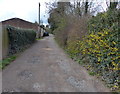
1
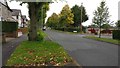
Glenville Avenue in Glen Parva, Leicester
Image: © Mat Fascione
Taken: 12 Oct 2019
0.13 miles
3
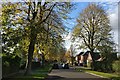
Glenville Avenue in Glen Parva, Leicester
Image: © Mat Fascione
Taken: 25 Oct 2017
0.15 miles
6
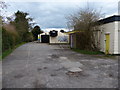
Factories along Rowlands Way in Glen Parva
Image: © Mat Fascione
Taken: 23 Mar 2014
0.16 miles
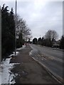
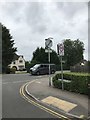
9
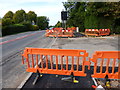
Road works on the A426 Leicester Road
Part of the long running A426 Bus Corridor Project.
Image: © Mat Fascione
Taken: 27 Sep 2013
0.19 miles
10
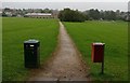
Path across the recreation ground
In Glen Parva, Leicester.
Image: © Mat Fascione
Taken: 21 Sep 2017
0.24 miles