IMAGES TAKEN NEAR TO
Leicester Road, LEICESTER, LE2 9HH
Introduction
This page details the photographs taken nearby to Leicester Road, LE2 9HH by members of the Geograph project.
The Geograph project started in 2005 with the aim of publishing, organising and preserving representative images for every square kilometre of Great Britain, Ireland and the Isle of Man.

There are currently over 7.5m images from over14,400 individuals and you can help contribute to the project by visiting https://www.geograph.org.uk
Image Map
Images are licensed for reuse under creativecommons.org/licenses/by-sa/2.0
Notes
- Clicking on the map will re-center to the selected point.
- The higher the marker number, the further away the image location is from the centre of the postcode.
Image Listing (19 Images Found)
Images are licensed for reuse under creativecommons.org/licenses/by-sa/2.0
Image
Details
Distance
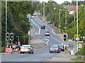
3
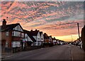
Lutterworth Road in Glen Parva, Leicester
Image: © Mat Fascione
Taken: 21 Sep 2017
0.07 miles
4
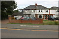
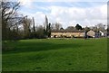
Houses on Leicester Road, Glen Parva
The roof has just been finished.
Image: © David Howard
Taken: 2 Jul 2023
0.08 miles
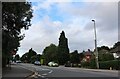
5
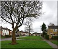
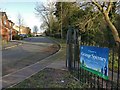
Green space near Ambleside Drive in Eyres Monsell
Image: © Mat Fascione
Taken: 23 Mar 2017
0.11 miles
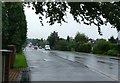
7
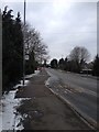
Red House Road in Eyres Monsell, Leicester
Image: © Mat Fascione
Taken: 20 Mar 2017
0.16 miles
9
Grange Spinney and Keswick Close
In Eyres Monsell, Leicester.
Image: © Mat Fascione
Taken: 6 Mar 2017
0.19 miles
10
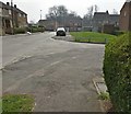
Ebchester Road in Eyres Monsell, Leicester
Image: © Mat Fascione
Taken: 28 Mar 2017
0.19 miles