IMAGES TAKEN NEAR TO
Watkin Road, LEICESTER, LE2 7AZ
Introduction
This page details the photographs taken nearby to Watkin Road, LE2 7AZ by members of the Geograph project.
The Geograph project started in 2005 with the aim of publishing, organising and preserving representative images for every square kilometre of Great Britain, Ireland and the Isle of Man.

There are currently over 7.5m images from over14,400 individuals and you can help contribute to the project by visiting https://www.geograph.org.uk
Image Map
Images are licensed for reuse under creativecommons.org/licenses/by-sa/2.0
Notes
- Clicking on the map will re-center to the selected point.
- The higher the marker number, the further away the image location is from the centre of the postcode.
Image Listing (252 Images Found)
Images are licensed for reuse under creativecommons.org/licenses/by-sa/2.0
Image
Details
Distance
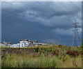
2
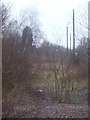
Abandoned railway yard, Leicester
This is where the track approached a railway yard. The posts for lighting and telegraph wires are still standing, but the track has been taken up and the area is slowly returning to nature.
The modern lights in the background have been installed along the Great Central Way, a footpath and cycle route which use the former Great Central Railway main line at this location.
Image: © Malc McDonald
Taken: 27 Feb 2011
0.03 miles
3
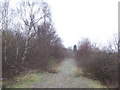
Dismantled railway, Leicester
This is the trackbed of a former railway line. The track has been taken up, leaving just the ballast path which is slowly becoming overgrown by nature.
Image: © Malc McDonald
Taken: 27 Feb 2011
0.03 miles
4
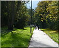
Great Central Way cycleway and footpath, Leicester
Image: © Mat Fascione
Taken: 28 Oct 2017
0.04 miles
6
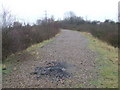
Railway trackbed, Leicester
This used to be a railway line. The track has been removed, but the ballast remains.
The track here had branched off the Great Central Railway, which ran north-to-south, and climbed as it curved round to join the Leicester to Burton-on-Trent route, which runs west-to-east. The Leicester to Burton tracks are behind the trees in the middle distance.
Image: © Malc McDonald
Taken: 27 Feb 2011
0.07 miles
9
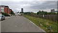
Watkin Road at Freemans Meadow, Leicester
Image: © Mat Fascione
Taken: 9 Jul 2019
0.08 miles
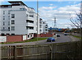
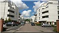
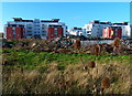
10

Freemans Meadow Apartments
Under construction alongside the Grand Union Canal in Leicester.
Image: © Mat Fascione
Taken: 28 Nov 2008
0.08 miles