IMAGES TAKEN NEAR TO
The Spinney, LEICESTER, LE2 4QS
Introduction
This page details the photographs taken nearby to The Spinney, LE2 4QS by members of the Geograph project.
The Geograph project started in 2005 with the aim of publishing, organising and preserving representative images for every square kilometre of Great Britain, Ireland and the Isle of Man.

There are currently over 7.5m images from over14,400 individuals and you can help contribute to the project by visiting https://www.geograph.org.uk
Image Map
Images are licensed for reuse under creativecommons.org/licenses/by-sa/2.0
Notes
- Clicking on the map will re-center to the selected point.
- The higher the marker number, the further away the image location is from the centre of the postcode.
Image Listing (5 Images Found)
Images are licensed for reuse under creativecommons.org/licenses/by-sa/2.0
Image
Details
Distance
1
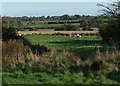
Stretton Hall housing estate
Looking east from Gorse Lane, the houses are along Chestnut Drive.
Image: © Mat Fascione
Taken: 13 Mar 2011
0.13 miles
2

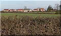
Housing Estate
An enclave of large modern houses is to be found adjacent to the site of the former Stretton Hall Hospital.
Image: © Andrew Tatlow
Taken: 2 Aug 2006
0.14 miles
4
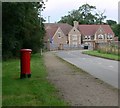
Chestnut Drive
This is a new housing estate called Stretton Hall.
Image: © Mat Fascione
Taken: 19 Jul 2007
0.24 miles