IMAGES TAKEN NEAR TO
Salts Close, LEICESTER, LE19 4SQ
Introduction
This page details the photographs taken nearby to Salts Close, LE19 4SQ by members of the Geograph project.
The Geograph project started in 2005 with the aim of publishing, organising and preserving representative images for every square kilometre of Great Britain, Ireland and the Isle of Man.

There are currently over 7.5m images from over14,400 individuals and you can help contribute to the project by visiting https://www.geograph.org.uk
Image Map (Loading...)


Getting Data...Please wait
Leaflet Map data © OpenStreetMap
Images are licensed for reuse under creativecommons.org/licenses/by-sa/2.0
Notes
- Clicking on the map will re-center to the selected point.
- The higher the marker number, the further away the image location is from the centre of the postcode.
Image Listing (9 Images Found)
Images are licensed for reuse under creativecommons.org/licenses/by-sa/2.0
Image
Details
Distance
1
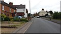
Mill Lane
The photograph shows housing in Mill Lane, Enderby.
Image: © Peter Mackenzie
Taken: 24 Jun 2017
0.09 miles
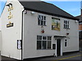
2
Enderby Nags Head
41 Cross Street. Locals pub in the heart of the village.
Image: © the bitterman
Taken: 28 Oct 2009
0.17 miles
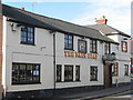
4
Enderby Dog & Gun
9 Cross Street. Marstons pub in village centre.
Image: © the bitterman
Taken: 28 Oct 2009
0.23 miles
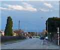
5
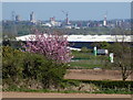
View towards the Leicester city skyline
Viewed from the B582 Blaby Road in Enderby.
Image: © Mat Fascione
Taken: 14 Apr 2020
0.23 miles
7

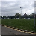
Brockington College
A modern college building in Enderby, Leicester.
Image: © Peter Mackenzie
Taken: 24 Jun 2017
0.24 miles
8
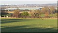
View towards Leicester
From Blaby Road in Enderby.
Image: © Mat Fascione
Taken: 19 Mar 2011
0.24 miles
9
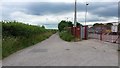
Kirk Lane
Kirk Lane, Enderby, Leicester.
Image: © Peter Mackenzie
Taken: 24 Jun 2017
0.25 miles