IMAGES TAKEN NEAR TO
Lubbesthorpe Bridle Road, LEICESTER, LE19 4LL
Introduction
This page details the photographs taken nearby to Lubbesthorpe Bridle Road, LE19 4LL by members of the Geograph project.
The Geograph project started in 2005 with the aim of publishing, organising and preserving representative images for every square kilometre of Great Britain, Ireland and the Isle of Man.

There are currently over 7.5m images from over14,400 individuals and you can help contribute to the project by visiting https://www.geograph.org.uk
Image Map (Loading...)


Getting Data...Please wait
Leaflet Map data © OpenStreetMap
Images are licensed for reuse under creativecommons.org/licenses/by-sa/2.0
Notes
- Clicking on the map will re-center to the selected point.
- The higher the marker number, the further away the image location is from the centre of the postcode.
Image Listing (138 Images Found)
Images are licensed for reuse under creativecommons.org/licenses/by-sa/2.0
Image
Details
Distance
2
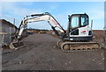
Construction work next to the Lubbesthorpe Bridle Road
Part of the early stages of building New Lubbesthorpe.
New Lubbesthorpe will be a housing development of 4,250 homes, built on a site that lies to the west of the M1, east of Beggar’s Lane, south of Leicester Forest East and north and south of the M69.
Image: © Mat Fascione
Taken: 16 Jan 2016
0.02 miles
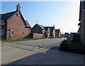
6
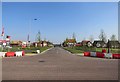
Tweed Street at Hereswode, New Lubbesthorpe
This is the point where the Lubbesthorpe Bridle Road will cross the road.
Hereswode is a new housing development, it is one of the first parts to be built of a much larger development known as New Lubbesthorpe.
New Lubbesthorpe is 4,250 homes being built on a site that lies to the west of the M1, east of Beggar’s Lane, south of Leicester Forest East and north and south of the M69.
Image: © Mat Fascione
Taken: 15 Jul 2017
0.03 miles
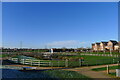
7
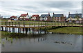
Balancing pond at Hereswode
Hereswode is a new housing development, it is one of the first parts to be built of a much larger development known as New Lubbesthorpe.
New Lubbesthorpe is 4,250 homes being built on a site that lies to the west of the M1, east of Beggar’s Lane, south of Leicester Forest East and north and south of the M69.
Image: © Mat Fascione
Taken: 15 Jul 2017
0.03 miles
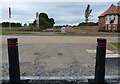
8
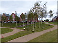
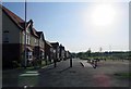
Public open space at Hereswode
Hereswode is a new housing development, it is one of the first parts to be built of a much larger development known as New Lubbesthorpe.
New Lubbesthorpe is 4,250 homes being built on a site that lies to the west of the M1, east of Beggar’s Lane, south of Leicester Forest East and north and south of the M69.
Image: © Mat Fascione
Taken: 15 Jul 2017
0.03 miles
9
SuDS retention pond, New Lubbesthorpe housing development
Image: © Tim Heaton
Taken: 9 Dec 2022
0.03 miles