IMAGES TAKEN NEAR TO
Irvine Crescent, LEICESTER, LE19 4BT
Introduction
This page details the photographs taken nearby to Irvine Crescent, LE19 4BT by members of the Geograph project.
The Geograph project started in 2005 with the aim of publishing, organising and preserving representative images for every square kilometre of Great Britain, Ireland and the Isle of Man.

There are currently over 7.5m images from over14,400 individuals and you can help contribute to the project by visiting https://www.geograph.org.uk
Image Map
Images are licensed for reuse under creativecommons.org/licenses/by-sa/2.0
Notes
- Clicking on the map will re-center to the selected point.
- The higher the marker number, the further away the image location is from the centre of the postcode.
Image Listing (67 Images Found)
Images are licensed for reuse under creativecommons.org/licenses/by-sa/2.0
Image
Details
Distance
1
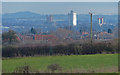
View towards the city of Leicester
The three tall buildings are part of the Leicester University Campus. On the left is the Charles Wilson building, in the centre is the Attenborough Tower, with the Engineering Building on the right. They are 4 miles away.
The high ground on the left horizon is Billesdon Coplow, over eleven miles away in east Leicestershire.
Image: © Mat Fascione
Taken: 19 Jan 2014
0.07 miles
2
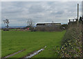
Farmland next to Old Warren Farm
This view will be very different in the years to come, as this is the site of the proposed New Lubbesthorpe housing development, 4,250 homes will be built on a site that lies to the west of the M1, east of Beggar’s Lane, south of Leicester Forest East and north and south of the M69.
Image: © Mat Fascione
Taken: 19 Jan 2014
0.07 miles
3
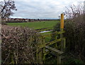
Stile and footpath on the edge of Leicester Forest East
The footpath is heading across the farmland towards the Thorpe Astley area of Leicester.
This view will be very different in the years to come, as this is the site of the proposed New Lubbesthorpe housing development, 4,250 homes will be built on a site that lies to the west of the M1, east of Beggar’s Lane, south of Leicester Forest East and north and south of the M69.
Image: © Mat Fascione
Taken: 19 Jan 2014
0.07 miles
4
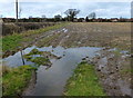
Muddy farmland on the edge of Leicester Forest East
Image: © Mat Fascione
Taken: 19 Jan 2014
0.07 miles
5
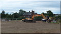
Building site next to Old Warren Farm
This is the site of the New Lubbesthorpe housing development, 4,250 homes will be built on a site that lies to the west of the M1, east of Beggar’s Lane, south of Leicester Forest East and north and south of the M69.
Image: © Mat Fascione
Taken: 15 Jul 2017
0.08 miles
7
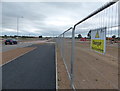
New road and cyclepath at New Lubbesthorpe
This is the site of the New Lubbesthorpe housing development, 4,250 homes will be built on a site that lies to the west of the M1, east of Beggar’s Lane, south of Leicester Forest East and north and south of the M69.
Image: © Mat Fascione
Taken: 15 Jul 2017
0.08 miles
8
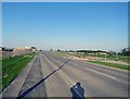
Tay Road eastwards
Construction of the Lubbesthorpe Primary School began in Summer 2018 in the area to the left; it is schedules to open as part of the OWLS Academy Trust in September 2019.
Image: © Andrew Tatlow
Taken: 7 May 2018
0.09 miles

