IMAGES TAKEN NEAR TO
Tay Road, LEICESTER, LE19 4BF
Introduction
This page details the photographs taken nearby to Tay Road, LE19 4BF by members of the Geograph project.
The Geograph project started in 2005 with the aim of publishing, organising and preserving representative images for every square kilometre of Great Britain, Ireland and the Isle of Man.

There are currently over 7.5m images from over14,400 individuals and you can help contribute to the project by visiting https://www.geograph.org.uk
Image Map (Loading...)


Getting Data...Please wait
Leaflet Map data © OpenStreetMap
Images are licensed for reuse under creativecommons.org/licenses/by-sa/2.0
Notes
- Clicking on the map will re-center to the selected point.
- The higher the marker number, the further away the image location is from the centre of the postcode.
Image Listing (116 Images Found)
Images are licensed for reuse under creativecommons.org/licenses/by-sa/2.0
Image
Details
Distance
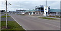
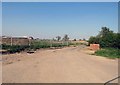
1

Tay Road in New Lubbesthorpe
New Lubbesthorpe is a new 'town' on the south-west edge of the city of Leicester. Proposals were first made in 2008, the plans were approved in 2014, the first homeowners moved in during 2017. When the development is finished it will include 4,250 homes.
The £7 million New Lubbesthorpe Primary School was opened in September 2019.
Image: © Mat Fascione
Taken: 21 Oct 2021
0.00 miles
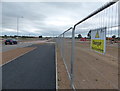
2
Primary school under construction on Tay Road
A £7 million, 420 place primary school along Tay Road in New Lubbesthorpe, due for completion in September 2019.
Image: © Mat Fascione
Taken: 3 Nov 2018
0.03 miles
3
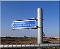
Sign on footpath to Leicester Forest East
The new Lubbesthorpe Primary School will be in the area beyond the sign. Construction of the school began in Summer 2018; it is scheduled to open as part of the OWLS Academy Trust in September 2019.
Image: © Andrew Tatlow
Taken: 7 May 2018
0.04 miles
4
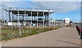
Primary school under construction
A £7 million, 420 place primary school along Tay Road in New Lubbesthorpe, due for completion in September 2019.
Image: © Mat Fascione
Taken: 3 Nov 2018
0.04 miles

6
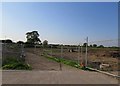
Footpath to Leicester Forest East
The new Lubbesthorpe Primary School will be in the area to the right. Construction of the school began in Summer 2018; it is scheduled to open as part of the OWLS Academy Trust in September 2019.
Image: © Andrew Tatlow
Taken: 7 May 2018
0.05 miles
7

New Lubbesthorpe Primary School
New Lubbesthorpe is a new 'town' on the south-west edge of the city of Leicester. Proposals were first made in 2008, the plans were approved in 2014, the first homeowners moved in during 2017. When the development is finished it will include 4,250 homes.
This £7 million primary school opened in September 2019.
Image: © Mat Fascione
Taken: 23 Sep 2021
0.05 miles
9
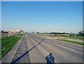
Tay Road eastwards
Construction of the Lubbesthorpe Primary School began in Summer 2018 in the area to the left; it is schedules to open as part of the OWLS Academy Trust in September 2019.
Image: © Andrew Tatlow
Taken: 7 May 2018
0.06 miles
10
New road and cyclepath at New Lubbesthorpe
This is the site of the New Lubbesthorpe housing development, 4,250 homes will be built on a site that lies to the west of the M1, east of Beggar’s Lane, south of Leicester Forest East and north and south of the M69.
Image: © Mat Fascione
Taken: 15 Jul 2017
0.07 miles