IMAGES TAKEN NEAR TO
The Burrows, LEICESTER, LE19 3WS
Introduction
This page details the photographs taken nearby to The Burrows, LE19 3WS by members of the Geograph project.
The Geograph project started in 2005 with the aim of publishing, organising and preserving representative images for every square kilometre of Great Britain, Ireland and the Isle of Man.

There are currently over 7.5m images from over14,400 individuals and you can help contribute to the project by visiting https://www.geograph.org.uk
Image Map
Images are licensed for reuse under creativecommons.org/licenses/by-sa/2.0
Notes
- Clicking on the map will re-center to the selected point.
- The higher the marker number, the further away the image location is from the centre of the postcode.
Image Listing (12 Images Found)
Images are licensed for reuse under creativecommons.org/licenses/by-sa/2.0
Image
Details
Distance
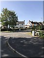
1
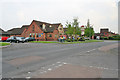
The Copt Oak, Narborough
A popular pub with young people, on Hardwicke Road opposite the junction with Copt Oak Road.
Image: © Kate Jewell
Taken: 12 May 2006
0.06 miles
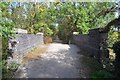
2
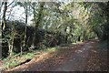
Dismantled Railway
A concrete retaining wall has been built along the old quarry railway line.
Image: © Ashley Dace
Taken: Unknown
0.17 miles
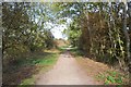
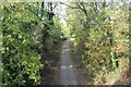
3
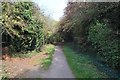
Former Quarry Line
The dismantled railway is now a cycle path.
Image: © Ashley Dace
Taken: Unknown
0.18 miles
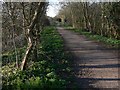
5
Dismantled Railway
The former quarry line is now a cycle and walking path of decent length.
Image: © Ashley Dace
Taken: Unknown
0.21 miles
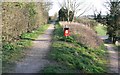
6
Whistle Way near Narborough
Public footpath and cycleway along an old railway line.
Image: © Mat Fascione
Taken: 19 Mar 2011
0.23 miles
7
Former Quarry Line
The former quarry line is now a cycle path.
Image: © Ashley Dace
Taken: Unknown
0.23 miles
10
Whistle Way near Narborough
Public footpath and cycleway along an old railway line.
Image: © Mat Fascione
Taken: 19 Mar 2011
0.24 miles