IMAGES TAKEN NEAR TO
Goscote Drive, LEICESTER, LE19 3ES
Introduction
This page details the photographs taken nearby to Goscote Drive, LE19 3ES by members of the Geograph project.
The Geograph project started in 2005 with the aim of publishing, organising and preserving representative images for every square kilometre of Great Britain, Ireland and the Isle of Man.

There are currently over 7.5m images from over14,400 individuals and you can help contribute to the project by visiting https://www.geograph.org.uk
Image Map (Loading...)


Getting Data...Please wait
Leaflet Map data © OpenStreetMap
Images are licensed for reuse under creativecommons.org/licenses/by-sa/2.0
Notes
- Clicking on the map will re-center to the selected point.
- The higher the marker number, the further away the image location is from the centre of the postcode.
Image Listing (8 Images Found)
Images are licensed for reuse under creativecommons.org/licenses/by-sa/2.0
Image
Details
Distance
4
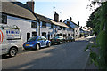
Coventry Road, Narborough
Terraced cottages built right up to the narrow road. Narborough is a large village to the south west of Leicester now part of the commuter belt.
Image: © Kate Jewell
Taken: 5 May 2006
0.20 miles
6
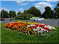
Roundabout on the B4114
The flowers are on the corner of Desford Road.
Image: © Mat Fascione
Taken: 7 Sep 2014
0.22 miles