IMAGES TAKEN NEAR TO
Camelot Way, LEICESTER, LE19 3BT
Introduction
This page details the photographs taken nearby to Camelot Way, LE19 3BT by members of the Geograph project.
The Geograph project started in 2005 with the aim of publishing, organising and preserving representative images for every square kilometre of Great Britain, Ireland and the Isle of Man.

There are currently over 7.5m images from over14,400 individuals and you can help contribute to the project by visiting https://www.geograph.org.uk
Image Map (Loading...)


Getting Data...Please wait
Leaflet Map data © OpenStreetMap
Images are licensed for reuse under creativecommons.org/licenses/by-sa/2.0
Notes
- Clicking on the map will re-center to the selected point.
- The higher the marker number, the further away the image location is from the centre of the postcode.
Image Listing (14 Images Found)
Images are licensed for reuse under creativecommons.org/licenses/by-sa/2.0
Image
Details
Distance


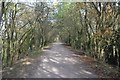
6

Former Quarry Line
The long disused railway line to the diorite quarry has been converted into a cycleway.
Image: © Ashley Dace
Taken: Unknown
0.18 miles
7
Former Quarry Line
A large embankment shows the quarry company put a lot of money into this freight branch.
Image: © Ashley Dace
Taken: Unknown
0.18 miles
8

Whistle Way near Narborough
Public footpath and cycleway along an old railway line.
Image: © Mat Fascione
Taken: 19 Mar 2011
0.19 miles
9
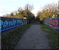
Graffiti covered former railway bridge
Along the Whistle Way cycleway and footpath, on the edge of Narborough.
Image: © Mat Fascione
Taken: 22 Dec 2013
0.20 miles