IMAGES TAKEN NEAR TO
Clarks Close, LEICESTER, LE19 2EB
Introduction
This page details the photographs taken nearby to Clarks Close, LE19 2EB by members of the Geograph project.
The Geograph project started in 2005 with the aim of publishing, organising and preserving representative images for every square kilometre of Great Britain, Ireland and the Isle of Man.

There are currently over 7.5m images from over14,400 individuals and you can help contribute to the project by visiting https://www.geograph.org.uk
Image Map (Loading...)


Getting Data...Please wait
Leaflet Map data © OpenStreetMap
Images are licensed for reuse under creativecommons.org/licenses/by-sa/2.0
Notes
- Clicking on the map will re-center to the selected point.
- The higher the marker number, the further away the image location is from the centre of the postcode.
Image Listing (4 Images Found)
Images are licensed for reuse under creativecommons.org/licenses/by-sa/2.0
Image
Details
Distance
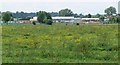
2
Ratby Meadow Lane
At St Johns near Enderby.
Image: © Mat Fascione
Taken: 7 Jul 2007
0.17 miles
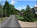
3
Barr Close in Enderby
New housing at St Johns in Enderby.
Image: © Mat Fascione
Taken: 2 Jan 2015
0.19 miles
4
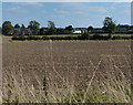
Farmland next to the Fosse Way
The houses are along the B4114 at St John's.
Image: © Mat Fascione
Taken: 7 Sep 2014
0.24 miles