IMAGES TAKEN NEAR TO
Roy Close, LEICESTER, LE19 2DN
Introduction
This page details the photographs taken nearby to Roy Close, LE19 2DN by members of the Geograph project.
The Geograph project started in 2005 with the aim of publishing, organising and preserving representative images for every square kilometre of Great Britain, Ireland and the Isle of Man.

There are currently over 7.5m images from over14,400 individuals and you can help contribute to the project by visiting https://www.geograph.org.uk
Image Map
Images are licensed for reuse under creativecommons.org/licenses/by-sa/2.0
Notes
- Clicking on the map will re-center to the selected point.
- The higher the marker number, the further away the image location is from the centre of the postcode.
Image Listing (10 Images Found)
Images are licensed for reuse under creativecommons.org/licenses/by-sa/2.0
Image
Details
Distance

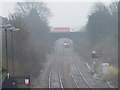
4
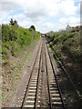
Railway line at Narborough
Viewed from the Regent Street railway bridge, this track joins Nuneaton with Leicester. Ahead, the bridge you can see carries M1 motorway traffic.
Image: © Neil Theasby
Taken: 14 Apr 2014
0.14 miles
5
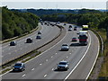
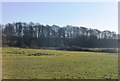
Looking south along the M1 motorway
On the horizon are the four turbines at the Low Spinney wind farm, 9.5 kilometres away.
Image: © Mat Fascione
Taken: 7 Sep 2014
0.16 miles
6
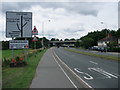
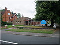
Entering Narborough along Leicester Road
The bridge carries the M1
Image: © Tim Heaton
Taken: 23 Jul 2011
0.17 miles
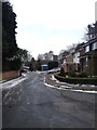
7
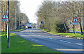
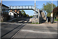
Regent Street crosses the South Leicestershire Railway
Image: © Tim Glover
Taken: 21 Feb 2011
0.18 miles
9
Narborough Station
Taken from the Station Road level crossing looking towards Leicester. This is the Birmingham to Stansted line.
Image: © Kate Jewell
Taken: 5 May 2006
0.20 miles