IMAGES TAKEN NEAR TO
Kenilworth Road, WIGSTON, LE18 4XT
Introduction
This page details the photographs taken nearby to Kenilworth Road, LE18 4XT by members of the Geograph project.
The Geograph project started in 2005 with the aim of publishing, organising and preserving representative images for every square kilometre of Great Britain, Ireland and the Isle of Man.

There are currently over 7.5m images from over14,400 individuals and you can help contribute to the project by visiting https://www.geograph.org.uk
Image Map
Images are licensed for reuse under creativecommons.org/licenses/by-sa/2.0
Notes
- Clicking on the map will re-center to the selected point.
- The higher the marker number, the further away the image location is from the centre of the postcode.
Image Listing (8 Images Found)
Images are licensed for reuse under creativecommons.org/licenses/by-sa/2.0
Image
Details
Distance
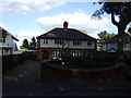
1
Kenilworth Road, South Wigston
From the corner of Kent Crescent.
Image: © Stephen Sweeney
Taken: 18 Jun 2011
0.04 miles
2
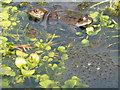
Frogs and Spawn
My garden pond is full of frogs and spawn
Image: © Jill Everington
Taken: 15 Mar 2007
0.10 miles
3
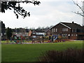
Playground William Gunning Park
Playground with Fairfield Pub in background
Image: © Jill Everington
Taken: 8 Mar 2007
0.14 miles
4
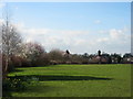
William Gunning Park South Wigston
Looking across open park land
Image: © Jill Everington
Taken: 8 Mar 2007
0.16 miles
5
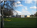
Fairfield Primary School South Wigston
Taken from footpath in William Gunning Park
Image: © Jill Everington
Taken: 8 Mar 2007
0.17 miles