IMAGES TAKEN NEAR TO
Waverley Road, WIGSTON, LE18 4UW
Introduction
This page details the photographs taken nearby to Waverley Road, LE18 4UW by members of the Geograph project.
The Geograph project started in 2005 with the aim of publishing, organising and preserving representative images for every square kilometre of Great Britain, Ireland and the Isle of Man.

There are currently over 7.5m images from over14,400 individuals and you can help contribute to the project by visiting https://www.geograph.org.uk
Image Map
Images are licensed for reuse under creativecommons.org/licenses/by-sa/2.0
Notes
- Clicking on the map will re-center to the selected point.
- The higher the marker number, the further away the image location is from the centre of the postcode.
Image Listing (26 Images Found)
Images are licensed for reuse under creativecommons.org/licenses/by-sa/2.0
Image
Details
Distance
1
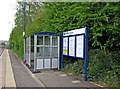
South Wigston Railway Station waiting room, South Wigston
Waiting room is perhaps too grand a term for what is basically an enlarged version of a bus shelter. This, the information board with train times, and the platform lighting, are the only facilities to be found here. This is the platform on the north side of the tracks. Similar facilities are to be found on the other platform.
Image
Image: © P L Chadwick
Taken: 15 Apr 2011
0.09 miles
2
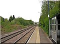
South Wigston Railway Station, South Wigston
The station is on the line from Birmingham to Leicester via Hinckley, but many trains do not stop here. The station's platforms are staggered, and this is the one on the north side of the tracks. The other platform is on the other side of the footbridge.
In the distance can be seen tracks coming in from the left. There is in fact a triangle of tracks in this area. The arrangement used to be even more complicated, as there was a further line going to Rugby, which cut across part of the triangle, but that closed decades ago. There used to be three stations in this area, but all were closed and replaced by the present South Wigston station, which is about as basic as can be.
Image
Image: © P L Chadwick
Taken: 15 Apr 2011
0.09 miles
3
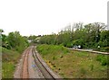
Glen Parva Junction
Photographed looking east from Saffron Road Bridge towards South Wigston Station.
Image: © Mat Fascione
Taken: 14 Apr 2007
0.09 miles
4
Train passing through South Wigston Station
Image: © Mat Fascione
Taken: 15 Feb 2015
0.09 miles
5
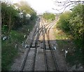
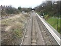
Railway lines at South Wigston
The railway lines here are part of the triangle of lines at South Wigston. On the right can be seen the northern platform of South Wigston Railway Station, with it bus shelter style waiting room.
Image
Image
Image: © P L Chadwick
Taken: 15 Apr 2011
0.10 miles
6
East bound platform at South Wigston railway station
Image: © Tim Glover
Taken: 29 Mar 2008
0.10 miles
7
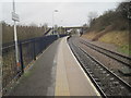
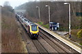
South Wigston railway station, Leicestershire
Opened by 1986 by British Rail on the line from Leicester to Birmingham.
View west towards Blaby and Birmingham. The eastbound platform can just be seen beyond the first overbridge. Beyond the second overbridge was the site of Wigston Glen Parva station (1884-1968).
Image: © Nigel Thompson
Taken: 6 Feb 2016
0.11 miles
8
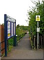
Footpath from Kenilworth Road to South Wigston Railway Station, South Wigston
The footpath commences at the end of Kenilworth Road, by the railway footbridge. The footpath leads to the platform on the north side of the railway. The bus shelter type waiting room can be seen in the distance. To reach the other platform, it is necessary to cross the footbridge.
Image: © P L Chadwick
Taken: 15 Apr 2011
0.11 miles
9
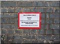
Notice on Footbridge at South Wigston Railway Station, South Wigston
This notice is to be found at the north end of the footbridge. It tells people what number to ring if a road vehicle bumps into the footbridge. The reference to the Railway Authority is strange as there never was such a body. It probably means the Strategic Rail Authority, which in one of the never-ending re-organisations so popular with politicians, was abolished in 2006 after just a few years life. The successor was Network Rail, but whether the phone number still applies is unknown.
Image
Image: © P L Chadwick
Taken: 15 Apr 2011
0.11 miles
10
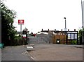
Footbridge at South Wigston Railway Station, South Wigston
Looking at the footbridge from the end of Kenilworth Road. The station's platforms are staggered. The platform on the north side is reached by taking a path to the right of the information board. The platform on the south side of the railway tracks is reached by crossing the footbridge. The footbridge also provides a way of easily reaching the shops and offices in Blaby Road.
Image
Image: © P L Chadwick
Taken: 15 Apr 2011
0.12 miles