IMAGES TAKEN NEAR TO
Wright Place, WIGSTON, LE18 4SY
Introduction
This page details the photographs taken nearby to Wright Place, LE18 4SY by members of the Geograph project.
The Geograph project started in 2005 with the aim of publishing, organising and preserving representative images for every square kilometre of Great Britain, Ireland and the Isle of Man.

There are currently over 7.5m images from over14,400 individuals and you can help contribute to the project by visiting https://www.geograph.org.uk
Image Map
Images are licensed for reuse under creativecommons.org/licenses/by-sa/2.0
Notes
- Clicking on the map will re-center to the selected point.
- The higher the marker number, the further away the image location is from the centre of the postcode.
Image Listing (61 Images Found)
Images are licensed for reuse under creativecommons.org/licenses/by-sa/2.0
Image
Details
Distance
1
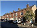
Kirkdale Road
Houses on Kirkdale Road in South Wigston.
Image: © Andrew Abbott
Taken: 26 Sep 2020
0.07 miles
2
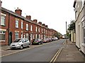
Kirkdale Road, South Wigston
The road is typical of the older ones in South Wigston, which only started to develop as a place of any size in the 1880's. This was mainly due to the activities of Orson Wright, who saw the potential of the area for industry and housing. Since then a lot, but not all, of the industry has gone, and like most places there have been many changes.
Image: © P L Chadwick
Taken: 15 Apr 2011
0.08 miles
3
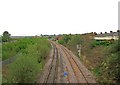
Railway lines at South Wigston
These lines are part of a triangle of lines at South Wigston. Over on the far left of the picture, can be glimpsed another set of lines, which also form part of the triangle.
Image
Image: © P L Chadwick
Taken: 15 Apr 2011
0.12 miles
4
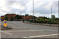
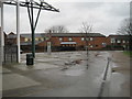
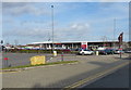
Junction on Blaby Road, South Wigston
The roundabout exit leads to Tesco.
Image: © David Howard
Taken: 2 Aug 2022
0.12 miles
5
Wigston South railway station (site), Leicestershire
Opened in 1840 on what became the Midland Railway's line from Leicester to Rugby, this station closed to passengers in 1962 and completely in 1966. All traces of the line have been removed.
View north east towards Leicester. As rebuilt in 1890 with 'staggered' platforms, the camera position is where the southbound platform was located. The line crossed the road straight ahead on a level crossing, and the northbound platform was where the left-hand side of the modern buildings are.
Image: © Nigel Thompson
Taken: 6 Feb 2016
0.13 miles
6
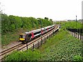
CrossCountry train passing South Wigston Railway Station, South Wigston
This CrossCountry diesel multiple unit service was rushing through South Wigston Railway Station when photographed. Like many trains, it was not scheduled to stop here. The station's south platform can be seen on the right, and the footpath which links it to the railway footbridge.
Image: © P L Chadwick
Taken: 15 Apr 2011
0.14 miles
7
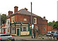
Former shop, Glengate, South Wigston
This former shop, now a private residence, is in the street known as Glengate, off Blaby Road. It is probably many years since it was used as a shop. When photographed, the building was for sale.
Image
Image: © P L Chadwick
Taken: 15 Apr 2011
0.14 miles
8
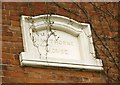
Former shop - detail, Glengate, South Wigston
On the flank wall of this former shop, is this stone inscribed with the name "Hawthorne House".
Image
Image: © P L Chadwick
Taken: 15 Apr 2011
0.14 miles
10
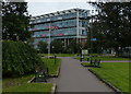
Path in the Blaby Road Park
Next to the South Leicestershire College in South Wigston.
Image: © Mat Fascione
Taken: 10 Sep 2017
0.15 miles