IMAGES TAKEN NEAR TO
Leopold Street, WIGSTON, LE18 4SW
Introduction
This page details the photographs taken nearby to Leopold Street, LE18 4SW by members of the Geograph project.
The Geograph project started in 2005 with the aim of publishing, organising and preserving representative images for every square kilometre of Great Britain, Ireland and the Isle of Man.

There are currently over 7.5m images from over14,400 individuals and you can help contribute to the project by visiting https://www.geograph.org.uk
Image Map
Images are licensed for reuse under creativecommons.org/licenses/by-sa/2.0
Notes
- Clicking on the map will re-center to the selected point.
- The higher the marker number, the further away the image location is from the centre of the postcode.
Image Listing (67 Images Found)
Images are licensed for reuse under creativecommons.org/licenses/by-sa/2.0
Image
Details
Distance
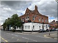
1
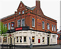
Marquis of Queensbury (1), 36-40 Blaby Road, South Wigston
This large pub stands on the corner of Blaby Road, and Fairfield Street. It dates from 1890, and used to be the Clarence Hotel. In those days it contained assembly rooms and the famous music hall star, Gertie Gitana, was one of the artists who performed there.
Image
Image
Image: © P L Chadwick
Taken: 15 Apr 2011
0.05 miles
2
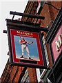
Marquis of Queensbury (2) - sign, 36-40 Blaby Road, South Wigston
The pub used to be the Clarence Hotel, but today is named after the 9th Marquis of Queensbury. The Marquis, in the 1860's, endorsed the rules under which boxing matches are still held today. Hence the sign shows a boxer of the Victorian era.
At the bottom of the sign something has been blocked out. Presumably this was a brewery, or pub chain, that once owned the pub.
Image
Image
Image: © P L Chadwick
Taken: 15 Apr 2011
0.05 miles
3
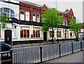
Marquis of Queensbury (3), 36-40 Blaby Road, South Wigston
The pub business occupies the ground floor of this large building, which used to be a hotel with assembly rooms. There have been proposals to use the upper floors for various community uses, and possibly this may have already started.
Image
Image
Image: © P L Chadwick
Taken: 15 Apr 2011
0.05 miles
5
Marquis of Queensbury
A public house on Blaby Road, South Wigston.
Image: © Andrew Abbott
Taken: 31 Aug 2020
0.06 miles
6
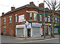
Moments, 2 Fairfield Street, South Wigston
Located on the corner of Fairfield Street and Blaby Street, with shop frontages to both. This is a shop specialising in balloons, gifts, partyware, fancy dress and personalised banners.
Image: © P L Chadwick
Taken: 15 Apr 2011
0.06 miles
8
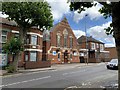
South Wigston Congregational Church
Erected in 1896 on Blaby Road, South Wigston. Architect James Tait of Leicester.
Image: © Andrew Abbott
Taken: 31 Aug 2020
0.06 miles
9
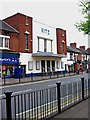
Ritz, 53-57 Blaby Road, South Wigston
This building started life in 1920 as The Picture House, an early cinema. In 1938 it received a new external facade, and was renamed the Ritz. It ceased to be a cinema in 1980, when like so many others it became a bingo hall, but retained the Ritz as its name. There are no notices outside, so possibly it is no longer in use for bingo.
Image: © P L Chadwick
Taken: 15 Apr 2011
0.07 miles
10
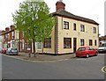
Kirkdale Road, South Wigston
The cream coloured building on the corner, which appears to be divided into two houses, looks as if it probably was originally a shop or maybe a pub.
Image: © P L Chadwick
Taken: 15 Apr 2011
0.07 miles