IMAGES TAKEN NEAR TO
Glengate, WIGSTON, LE18 4SQ
Introduction
This page details the photographs taken nearby to Glengate, LE18 4SQ by members of the Geograph project.
The Geograph project started in 2005 with the aim of publishing, organising and preserving representative images for every square kilometre of Great Britain, Ireland and the Isle of Man.

There are currently over 7.5m images from over14,400 individuals and you can help contribute to the project by visiting https://www.geograph.org.uk
Image Map
Images are licensed for reuse under creativecommons.org/licenses/by-sa/2.0
Notes
- Clicking on the map will re-center to the selected point.
- The higher the marker number, the further away the image location is from the centre of the postcode.
Image Listing (68 Images Found)
Images are licensed for reuse under creativecommons.org/licenses/by-sa/2.0
Image
Details
Distance
1
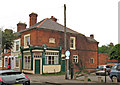
Former shop, Glengate, South Wigston
This former shop, now a private residence, is in the street known as Glengate, off Blaby Road. It is probably many years since it was used as a shop. When photographed, the building was for sale.
Image
Image: © P L Chadwick
Taken: 15 Apr 2011
0.05 miles
2
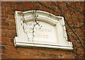
Former shop - detail, Glengate, South Wigston
On the flank wall of this former shop, is this stone inscribed with the name "Hawthorne House".
Image
Image: © P L Chadwick
Taken: 15 Apr 2011
0.05 miles
3
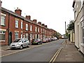
Kirkdale Road, South Wigston
The road is typical of the older ones in South Wigston, which only started to develop as a place of any size in the 1880's. This was mainly due to the activities of Orson Wright, who saw the potential of the area for industry and housing. Since then a lot, but not all, of the industry has gone, and like most places there have been many changes.
Image: © P L Chadwick
Taken: 15 Apr 2011
0.05 miles
4
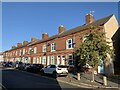
Kirkdale Road
Houses on Kirkdale Road in South Wigston.
Image: © Andrew Abbott
Taken: 26 Sep 2020
0.06 miles
5
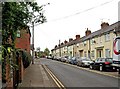
Kirkdale Road, South Wigston
One of South Wigston's older streets. South Wigston was mainly open fields until development started in the 1880's. See:- Image
Image: © P L Chadwick
Taken: 15 Apr 2011
0.08 miles
6
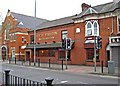
South Wigston Club & Institute, 105 Blaby Road, South Wigston
Originally a Working Men's Club, but that part of the title seems to have been dropped.
Image: © P L Chadwick
Taken: 15 Apr 2011
0.08 miles
7
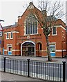
South Wigston Methodist Church (1), Blaby Road, South Wigston
The church was opened in 1902, and at that time it was a Wesleyan Methodist Church. In 1968 it amalgamated with a Primitive Methodist Church, which was based in Countesthorpe Road. The amalgamated church then took its present name. In 1971 major changes were completed to the interior of the church, including the insertion of a new floor level.
Image
Image: © P L Chadwick
Taken: 15 Apr 2011
0.08 miles
8
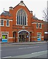
South Wigston Methodist Church (2), Blaby Road, South Wigston
The church was opened in 1902, with many alterations since. It replaced a chapel opened in December 1886, which had become too small because of the growing congregation.
Image
Image: © P L Chadwick
Taken: 15 Apr 2011
0.08 miles
9
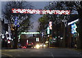
Christmas lights on Blaby Road in South Wigston
Image: © Mat Fascione
Taken: 3 Dec 2017
0.08 miles
10
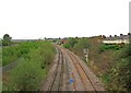
Railway lines at South Wigston
These lines are part of a triangle of lines at South Wigston. Over on the far left of the picture, can be glimpsed another set of lines, which also form part of the triangle.
Image
Image: © P L Chadwick
Taken: 15 Apr 2011
0.08 miles