IMAGES TAKEN NEAR TO
Ellison Close, WIGSTON, LE18 4QH
Introduction
This page details the photographs taken nearby to Ellison Close, LE18 4QH by members of the Geograph project.
The Geograph project started in 2005 with the aim of publishing, organising and preserving representative images for every square kilometre of Great Britain, Ireland and the Isle of Man.

There are currently over 7.5m images from over14,400 individuals and you can help contribute to the project by visiting https://www.geograph.org.uk
Image Map
Images are licensed for reuse under creativecommons.org/licenses/by-sa/2.0
Notes
- Clicking on the map will re-center to the selected point.
- The higher the marker number, the further away the image location is from the centre of the postcode.
Image Listing (67 Images Found)
Images are licensed for reuse under creativecommons.org/licenses/by-sa/2.0
Image
Details
Distance
1
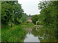
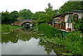
Grand Union Canal east of Blaby in Leicestershire
The housing is in Park Road.
Image: © Roger Kidd
Taken: 25 Aug 2013
0.07 miles
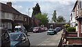
3
Canal towpath near South Wigston in Leicestershire
This is the towpath by the Grand Union Canal (Leicester Section), about two hundred metres east of Bush Lock.
Image: © Roger Kidd
Taken: 25 Aug 2013
0.08 miles
4
Grand Union Canal east of Blaby in Leicestershire
The housing is in Park Road. Ahead is Vice's Bridge, No 93.
Image: © Roger Kidd
Taken: 25 Aug 2013
0.08 miles
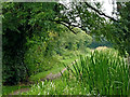
5
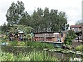
Canalside in South Wigston
On the Grand Union Canal.
Image: © Andrew Abbott
Taken: 31 Aug 2020
0.09 miles
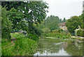
6

Grand Union Canal east of Blaby in Leicestershire
The Grand Union Canal (Leicester Section) is seen here approaching Vice's Bridge, No 93.
Image: © Roger Kidd
Taken: 25 Aug 2013
0.09 miles

8
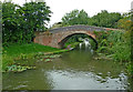
Vice's Bridge near South Wigston in Leicestershire
The Grand Union Canal (Leicester Section) is seen here approaching Vice's Bridge, No 93. The bridge was an accommodation bridge for the farmer, but land to the north (right) is no longer used for agriculture purposes. No public right of way crosses the bridge. In the distance is Bush Lock.
Image: © Roger Kidd
Taken: 25 Aug 2013
0.10 miles
9
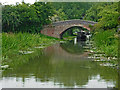
Canal near South Wigston in Leicestershire
The Grand Union Canal (Leicester Section) is seen here approaching Vice's Bridge, No 93. The bridge was an accommodation bridge for the farmer, but land to the north (right) is no longer used for agriculture purposes. No public right of way crosses the bridge.
Image: © Roger Kidd
Taken: 25 Aug 2013
0.10 miles
10
Vice's Bridge near South Wigston in Leicestershire
The Grand Union Canal (Leicester Section) is seen here approaching Vice's Bridge, No 93. The bridge was an accommodation bridge for the farmer, but land to the north (right) is no longer used for agriculture purposes. No public right of way crosses the bridge.
Image: © Roger Kidd
Taken: 25 Aug 2013
0.10 miles