IMAGES TAKEN NEAR TO
Harrington Road, WIGSTON, LE18 3WB
Introduction
This page details the photographs taken nearby to Harrington Road, LE18 3WB by members of the Geograph project.
The Geograph project started in 2005 with the aim of publishing, organising and preserving representative images for every square kilometre of Great Britain, Ireland and the Isle of Man.

There are currently over 7.5m images from over14,400 individuals and you can help contribute to the project by visiting https://www.geograph.org.uk
Image Map
Images are licensed for reuse under creativecommons.org/licenses/by-sa/2.0
Notes
- Clicking on the map will re-center to the selected point.
- The higher the marker number, the further away the image location is from the centre of the postcode.
Image Listing (11 Images Found)
Images are licensed for reuse under creativecommons.org/licenses/by-sa/2.0
Image
Details
Distance
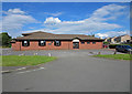
5
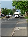
Estoril Avenue
Estoril Avenue passes the Glenmore Primary School which recently federated with the nearby Langmoor Primary School.
Image: © Andrew Tatlow
Taken: 11 Oct 2010
0.21 miles
7
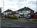
Cuisine of India: Kelmarsh Avenue, Wigston
Indian restaurant, previously the 1980s Meadow Bank pub.
Image: © Dylan Moore
Taken: 27 Jun 2016
0.23 miles
8
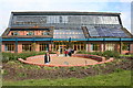
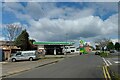
Brocks Hill Environmental Centre
Exciting building showing energy saving techniques. Courses, cafe and environmental areas. Great sundial using a body!
Image: © John Tomlinson
Taken: 16 Apr 2005
0.23 miles